NUMERICS AND GEOGRAPHY OF GILGAMESH TRAVELS
(Emilio Spedicato)
Abstract. We consider Gilgamesh travels, as described in the
surviving Gilgamesh epic. Assuming that the epic in based on actual travels,
we propose different itineraries than usually assumed. We claim that Gilgamesh
aimed to the heart of Asia, possibly the original land of the Sumerians,
via two different routes: one taking him through the Karakorum, the other
via the Balkash lake and most probably the Zungarian gates. Final aim was
a mountain range still now sacred to the local Ngolok tribe.
This work is dedicated:
to the late Leonard Clark,
whose adventures in Amazonian Peru fascinated my young years,
whose report of his military duty in Northern Tibet
opened a new light on the dawn of civilization,
in the year of my first flight over Amazonian Peru,
land of secrets to be unveiled
to the Ngolok
fierce tribe of North Tibet
preservers of the ancient sacred Anu Mashu mountain,
let them for ever own the land of their fathers
and keep faithful to their traditions
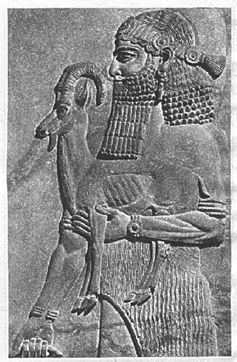
to Khubaba
and to the Yetis
peaceful creatures in the high mountains,
our genetic brothers,
hunted down by Homo Sapiens Sapiens,
by homo homini lupus.
Sunt nomina lumina
Oh, Geography Cinderella of sciences!
S.H. beautiful daughter of the Hunza people learn Burushaski language
of your ancestors language of a special people of a very special place...
1. Introduction
The Gilgamesh epic deals with the adventures of Gilgamesh,
king of the Sumerian city of Uruk (biblical Erech), son of the semigod
Lugalbanda and of the goddess Rimat Ninsun, hence himself two thirds "god",
one third man, but mortal as all men. The text of the epic is not known
in its entirety. The first tablets were found in the excavations of the
library of Assurbanipal (668-627 BC) in Ninive by Layard in the 1840s.
The first communication that these tablets contained a Chaldaic story of
the Universal Flood was made on December 3, 1872, in London, by the assyriologist
Smith. It is now known, see Pettinato (1992), that the epic in the version
of the Assurbanipal library (where apparently four copies were kept) consisted
of 12 large tablets, each one having about 300 lines, for an estimated
total of 3059 lines. Currently about 2000 lines are known. More may be
discovered in future excavations or more simply in the deposits of the
world museums. It is interesting to note that the first four lines of the
epic were found in September 1998 by Theodore Kwasmann while searching
among the collections of the British Museum (see the article of R.J. Head
in Odyssey, July-August 1999). The four lines, published in Nouvelles Assyriologiques
Brèves et Utilitaires, are given here in the original Assyrian text
and in their published translation:
(sha nagbu iimuru i) shdi maati
(xxx-ti iid) uu kalaama hhassu
(Gilgamesh sha n)agbu iimuru ishdi maati
(xxx-t)i iidu kallama hhassu
He who saw the nagbu (the countrys foundation)
who knew.... was wise in all matters!
Gilgamesh (who saw the nagbu), (the countrys foundation)
who knew.... was wise in all matters!
In the above translation the correct meaning of nagbu
was a point of discussion. In the Chicago Assyrian Dictionary the word
is translated as "totality" or "spring, fountain, source". We will see
at the end of this essay an intriguing relation with "spring", in both
a geographical and an ethnographical sense. In addition to the Assyrian
version of the epic found in Ninive, fragments in different languages,
including non semitic Hurrian, Sumerian and Hittite, have been found in
several locations in the Middle East, most of them predating Assurbanipal
time. At least ten documents are dated to the paleobabylonian period (i.e.
Hammurabis time, circa 1800 BC), while half a dozen documents in Sumerian
are dated to the second half of the third millennium BC. There is the intriguing
possibility that the epic was originally composed by an advisor of Gilgamesh
(no more a semigod apkallu, but a human ummanu), named Sileqiunnini,
see Pettinato (1992). About the historicity of Gilgamesh opinions are divided.
Gilgamesh is listed in ancient tablets as the fifth king of the first dynasty
of Uruk, often dated at the period 3500-3100 BC. Now the dendrochronological
record, see Baillie (1999), suggests that in the year 3195 BC a dramatic
climatic event occurred, possibly associated with a substantial world flooding
episode of extraterrestrial origin (i.e. a cometary or asteroidal impact
or the close passage of a large body). If the suggested flood event is
the one described as the Utnapishtim/Ziusudra flood in the Gilgamesh epic
(and as the Noah flood in Genesis, the Pygmalion flood in Greek traditions,
etc.), then the dating of the first Uruk dynasty should be lowered by a
few centuries. This would be in agreement with the chronological revision
proposed in the last fifty years by several authors, starting from Velikovsky
(1953), see in particular Rohl (1998), who dates Gilgamesh at circa 2500
BC. The following Tables provide some of Rohls dating.
Table 1: Rohls dating of First Uruk dynasty
| 3000 BC |
Heskiagkasher (biblical Cush) |
| 2900 BC |
Enmerkar (biblical Nimrod) |
| 2800 BC |
Lugalbanda |
| 2588 BC |
Dumuzi |
| 2487 BC |
Gilgamesh |
| 2348 BC |
Urlugal |
Table 2: Rohls dating of first four Egyptian dynasties
| 2789-2669 BC |
Menes and First dynasty |
| 2669-2514 BC |
Second dynasty |
| 2514-2459 BC |
Third dynasty |
| 2459-2350 BC |
Fourth dynasty |
Rohl dates the Flood to about 3100 BC, but has a discrepancy
in his chronology. Indeed he notices (p. 425 of his monograph) that a different
counting of dynasties lengths based upon the Turin Royal Canon would provide
2898 BC for Year 1 of Menes. If we take the suggested dendrochronological
dating (at 3195 BC) of the Flood and we notice that according to Manetho
there was in Egypt a period of 350 years of confusion and crisis before
Menes, a period that can be naturally explained as the aftermath of a huge
destructive flood, then we would have a date of 2845 BC for Year 1 of Menes,
about half way between the date provided by the Turin Canon and the date
in Table 2. In view of likely unavoidable errors that may affect both the
dendrochronological record (despite the high accuracy claimed by its proponents)
and the surviving lists (where coregencies have always been a question
difficult to extricate), it seems safe to conclude that the Flood should
be dated in the period between 3100 and 3200 BC. An additional support
for dating in this century a catastrophic climatic event is provided by
the analysis of ice cores at Camp Century, Greenland, where a large acid
layer has been identified and dated at 3150 plus or minus 50 BC. It is
interesting to note that another acid layer at Camp Century, dated at 1390
plus or minus 50, comes close to the dating of the Exodus at exactly 1447
BC, proposed first by Velikovsky (1953) and again claimed by Rohl (1995).
Both Velikovsky and Rohl have identified the pharaon of the Exodus with
the last pharaon of the 13th dynasty, the obscure Dudimose, whose name
appears in the Turin canon, and whose tragic kingdomship is certainly more
characterized by a great natural catastrophe and by the onslaught brought
by the Hyksos than by the departure of a few hundred thousand Hebrews.
In this paper we will not discuss the historicity of Gilgamesh and its
dating. We will not propose explanations of the extraordinary semigod qualities
that he shows in the epic (see for instance Sitchin (1980) for the nonstandard
interpretation of Gilgamesh mother "goddess", as a female belonging to
a group of extraterrestrial "gods" that according to him visited the Earth
in ancient times, "created" man by genetic engineering and were able to
copulate with their creatures, as also Genesis states with regard to the
Nephilim).
Under the assumption that the epic is based upon an actual travellers
experience, we will try to identify the routes in the two trips of Gilgamesh,
the first one to the "Forest of Cedars", the second one to the mountain
called "Mashu". Our proposed routes and final destinations are wholly different,
as far as we know, from those usually considered, these being not too far
from Sumer. We claim that Gilgamesh final destination was the heart of
Asia, the land where quite possibly the Sumerians came from, the land which
in the case of a catastrophical flood of extraterrestrial origin is the
best protected in the whole world from the effects of a global tsunami
and of long lasting torrential rains. According to our thesis Gilgamesh
tried to reach this land via the two most natural routes from Sumer. The
first one, shorter but of much more difficult terrain and of great altitude,
took him to the Karakorum passes (e.g. Kilik, 4755m, Mintaka, 4709m, or
Khunjerab, originally 4934m now after the construction of the Karakorum
highway reduced to 4602m), quite probably via Iran, Afghanistan, Kashmir
(Barda, Buner, Hazara, Kohistan, Dardistan, Punjal, Hunza), from which
he could have descended into the heart of Asia via eastern Pamir and the
Tarim basin region. This approach failed, probably for the extreme difficulty
of the Karakorum trails, often closed by landslides and snowslides, possibly
also for the failure of Gilgamesh to acclimitize to the high altitude of
the Karakorum passes. The two heroes consoled themselves by killing poor
Khubaba (we will suggest who Khubaba might have been) and by cutting a
large cedar tree that they brought back to Uruk. The second route is longer,
by some 3000 km, and went most probably through very little populated land.
It allowed however access to the heart of Asia by the much easier Zungarian
Gates pass, less than 500 meters. Mount Mashu, we claim, is the great sacred
mountain range surrounded on three sides by the Yellow River, still locally
called Maqu (pronounce "Machu"), whose sources are not far from it. The
mountain is sacred to the local north Tibetan Ngolok tribes and till the
fifties was closed to foreigners. Its name still bears obvious reference
to Mashu and to the highest god of the Sumerian pantheon.
2. The trip to the Forest of Cedars. Numerics and geographical
information in surviving tablets
The first trip takes Gilgamesh and Enkidu to the Forest
of Cedars, in a land called "Lebanon", which is reached overland. Here
they kill the monster Khubaba (in Assyrian; Huwawa in the Hittite text)
and cut a very big cedar to be taken to the temple of Enlil in Nippur.
They return to Uruk via water, navigating a river called "Euphrates". It
is commonly assumed that the Forest of Cedars is present Lebanon. The trip
is described in Tablets II 184 to V 266 in the Assurbanipal text, affected
by several lacunes, only partially remedied by use of the other texts.
For the following discussion of the route, here we report the passages
containing numerical and geographical information. These passages are translated
from the italian version of the whole corpus of surviving material given
by Pettinato (1992). We first give the passages from the Assyrian texts
in Assurbanipal library.
-
-
1. II, 184-193: Khubaba whose cry is stormy.....who can
hear at 60 leagues through the forest trees..... to protect the Forest
of Cedars he has been commanded by Enlil and a bodily fatigue takes possession
of anyone who tries to enter this forest....
-
-
2. II,221-224: I have made my mind. I will leave to the
far away land where Khubaba lives. I want to face a defy even if of uncertain
outcome, I want to explore an unknown way
-
-
3. III, 6-7: Let Enkidu preceed you, he knows the way
to the Forest of Cedars
-
-
4. III, 48-51: He (Gilgamesh) intends to take the long
travel to the place of Khubaba. He will engage a fight of uncertain outcome,
he will walk over unknown trails till the day when, after a long way, he
shall reach the Forest of Cedars.
-
-
5. IV, 1-6: After 20 leagues they took a meal, after 30
leagues they stopped for sleep, 50 leagues they had made in their daily
march, a distance of one month and a half they made in 3 days, reaching
the "mountains of Lebanon".
-
-
6. IV, 78: Gilgamesh ascended the mountain
-
-
7. IV, 84: ... spit blood...
-
-
8. IV, 87: was overwhelmed by sleep
-
-
9. IV, 100: let us go back to the steppes
-
-
10. IV, 91: why am I so nervous?
-
-
11. IV, 93: why do I feel so week?
-
-
12. IV, 207-208: ... a difficult trail, that a single
person cannot easily take, better to be in two...
-
-
13. V, 2: ...they were astounded at the height of the
cedars...
-
-
14. V, 5-8: there were nicely cut trails, they looked
at the mountain of cedars, the place where the gods dwell, the sanctuary
of Irnini, the cedar was tall and majestic...
-
-
15. V, 5 (Uruk version): when you (Enkidu) were young,
I saw you...
-
-
16. V, 255: Gilgamesh cut the trees...
-
-
17 V, 258-265: My friend, the wonderful cedar has been
cut, it no more reaches the sky. I want to use it to build a gate, of height
6 times 12 spans, one span of width, the lower and the upper hinges one
span. Let it be carried to Nippur by the Euphrates.... they put the trunk
in the river, Enkidu guided it, Gilgamesh was carrying the head of Khubaba.
-
-
Information from other sources:
-
-
18. Yale tablet, 165: They made axes of 3 talents each
-
-
19 Yale tablet, 170: Gilgamesh and Enkidu each one were
carrying ten talents of weapons
-
-
20 Yale tablet, 193: The forest extended 60 leagues in
each direction
-
-
21 Yale tablet, 247-250: Let Enkidu lead you, let him
check the way, he knows the access to the forest and every trick of Khubaba
-
-
22 Yale tablet, 255: May he (Shamash) open to you the
close trails
-
-
23 Yale tablet, 262-269: ...in the river of Khubaba, as
you wish, put your feet
-
-
24 Baghdad tablet 1-2: Climb the mountains crevasses,
the gods have taken away my sleep...
-
-
25 Hittite version: When they arrived to the shores of
Euphrates they made a sacrifice.... from there after 16 days they were
in the middle of the mountains.... then they looked at the cedars.... Gilgamesh
and Enkidu cut the cedars... when Huwawa heard the noise he got angry and
said: who has cut the cedars I have grown?....
-
-
26 Huwawa said: I will lift you, I will carry you up hill,
I will hit your head, I will put you in the black earth!
-
-
27 Gilgamesh and Khubaba, 53: Young men like him, in number
of 50, went with him...
-
-
28 Gilgamesh and Khubaba, 82: The sons of your city who
accompanied you should not wait long for you at the foot of the Mountain.
-
Remark. The "span" is about 60 cm. The "league",
Assyrian beru, is the distance walked in two hours, commonly estimated
at 10 km but possibly more, 15 km or more.
3. Identifying the location of the Forest of Cedars
From the above given texts, features of the Land of Cedars are the
following:
-
It is very far away
-
Enkidu knows the way
-
The taken overland route was previously "unknown", required a "long
wandering" and in the final stage goes through a difficult terrain "which
a simple person cannot easily take", where "it is better to be in two"
-
The forest is large, extending in each direction 60 leagues: it is located
in the "mountain of Lebanon"
-
A river crosses the forest; by putting the cedar in the waters of the
river one can finally reach Uruk
-
The trip can be divided in two stages. The first one, equivalent to
45 days of normal travel, takes the two friends to the "Euphrates river".
The second stage in 16 days takes them to the middle of the mountains.
-
From the secondary text Gilgamesh and Khubaba we know that 50
friends of Gilgamesh waited for him at the foot of the mountain. Since
they do not appear to have accompanied him along the new overland way,
this suggests that they reached the waiting point by a different, presumibly
easier and well known way.
-
Khubaba could hear "60 leagues" away; his way of dealing with his opponents
was quite peculiar: a hit on the head, lifting them, carrying them uphill,
putting them in the black earth.
It is usually assumed that the destination of Gilgamesh first trip was
some point in the mountains of present Lebanon, where cedars are known
to have existed since ancient times (only half a dozen of them still live
in the wild, well fenced in a national park). The identification of the
land with Lebanon seems supported in the text by references to Lebanon
and Euphrates, despite Lebanon is mainly a modern name for a country
in ancient times known as Phoenicia or with other names. It is our opinion
that this standard identification must be rejected on the following grounds:
-
it is in unresolvable conflict with a number of statements in the text
-
it leads to a feat which is almost certainly physically impossible
-
it is based upon a hasty identification of the names translated, albeit
not incorrectly, as "Lebanon" and "Euphrates", with the present state and
river in the Middle East
-
it does not correspond to a route defined in the text, especially for
the terminal phase, as new, very difficult and providing unusual bodily
effects.
Our proposal is that the Forest of Cedars was located in Kashmir, i.e.
in the mountainous region cut by the river Indus and its several affluents.
We will more precisely argue that the meeting with Khubaba took place in
the northern reaches of Kashmir, probably just north of the Hunza valley,
on the way to one of the passes (Khunjerab or more probably Mintaka, for
reasons that will be discussed in a forthcoming paper), that lead via eastern
Pamir to the Tarim basin (now mainly a desert, the Takla-Makan, but still
borderd by chains of oasis) and hence to China via the Yellow River valley.
The Hunza valley, about 100 km long, elevation between 1700 and 2500 meters,
is a very special place, with nice climate and where many fruits are grown.
Its natural access from Gilgit, about 120 km as the crow flies, was in
the past, before the opening of the Karakorum highway, extremely difficult,
taking over two weeks, see Bircher (1980). The approaches to the passes
at the end of the valley are also extremely steep and difficult. We will
argue that the word translated as "Euphrates" should more correctly and
meaningfully be translated as the "River of the cows" and should be identified
with the Hunza/Indus river, while "Lebanon" should be translated as "Land
of milk", this referring to the general high Kashmir region. We propose
that Gilgamesh and Enkidu reached the Indus via Iran and most probably
via southern Afghanistan, hence via the Khyber pass, reaching their friends
at the foot of the Kashmir mountains somewhere between present Peshawar
and Rawalpindi, not far from ancient Taxila, possibly at the meeting point
of the Kabul and Indus river (near present cities of Attock and Nowshera).
The 16 days of ascent to the "middle of the mountains" were most probably
first along the Indus (locally "Sind") river, then, after the Indus turns
in an easterly direction towards Ladakh via Baltistan, by following the
affluents Gilgit and Hunza. We identify, as said before, the "Middle of
the mountains" with the special Hunza valley, gently elevating from 1700
to 2500 meters, surrounded by steep montains, the river Hunza having a
rather deep bed crossing which is not so easy (different tribes live on
each side of of the river). The valley has about 200 villages, population
about 10.000 people at the time of Second World War, now over 35.000. Every
cultivable piece of land is used to produce cereals, vegetables and fruits
(some 20 varieties of superb tasting apricots, dried for the winter). Till
the construction of the Karakorum highway (opened in 1978 for special,
mainly military use, in 1986 to general passage, first European to cross
it Danziger, 11 October 1984, who filled the visa form n. 1 declaring himself
to be Donald Duck, see Danziger (1993)) which crosses the ridge at 4602
meters, the most used pass was the Mintaka pass (4709m), the one where
probably Gilgamesh was directed. The pass was used to import some products
from China, silk and a few objects of daily use. By this way, we surmise,
Gilgamesh intended to cross into the heart of Asia towards the sacred mount
Mashu that he reached by a longer easier way in his second trip. Our proposals
above are based upon the following considerations:
-
The Forest of Cedars. The so called cedar of Lebanon, scientific
name Cedrus Libanotica, presently grows wildly in extremely limited numbers
in Lebanon, Siria and southern Anatolia, but its greatest natural habitat,
in the variety Cedrus Deodara, is Kashmir, see Appendix 3. In view of the
thesis strongly argued for by Kamal Salibi (1988, 1996, 1998) that the
Hebrews previous to their deportation first to Assyria by Sargon II (722
BC), then to Babylon by Nebuchadnezzar (587 BC), were living on the mountains
of south-western Arabia (present Asir/Yemen region) and that the Phoenicians
too originally lived along the arabian coasts of the Red Sea, it may even
be argued that Kashmir, and not Lebanon, was the main source of cedar wood
in ancient biblical times. See again Appendix 3 for the fact that Cedrus
Deodara is the standard timber used even now in Asia for religious works.
The timber had to be brought to the Red Sea by Phoenicians via the Indus
river and the Indian Ocean. Trade of timber is well documented to Sumer
from the Indus valley, not necessarily by Phoenicians. A further argument
that the Forest of Cedars was not in Lebanon is the huge size given in
the text. The forest is said to have an extension of "60 leagues", i.e.
at least 600 km., in each direction. Such size is incompatible with the
small dimensions of Lebanon. Jebel Liban is about 120 km long and no more
than 40 km wide, Jebel el Sharqui (the Antilebanon) is even smaller. If
the Kashmir region is defined by the mountain area whose waters feed the
Indus, then this region is roughly a rectangle of over 700 by 500 km, in
excellent agreement with the epic statement. It should be noted that Kashmir,
now partially deforested, was in ancient times almost fully covered by
forests (of course only partly consisting of cedar trees!), thanks to the
rains brought by the monsoons. The tree line now approaches 4000 meters
and barley can be grown up to 4400 meters on the slopes of the Hunza valley.
At Gilgamesh time, around the middle of the third millennium BC according
to Rohls revised chronology, which we deem to be basically correct, the
world
was experiencing a climatic optimum, with a megalitic civilization thriving
in northern Europe, grape growing in Sweeden, wetter conditions in many
regions now very arid, including central Asia, hence the tree line might
have been even higher.
-
The terms Lebanon and Euphrates. What is usually translated
as "Lebanon" is a semitic word that in say the original, purely consonantal
(vocalization was introduced only between the 5th and 8th century AD by
the Masoretes, when ancient Hebraic was no more spoken since almost one
thousand years) biblical text reads as LBN. We think it is correct to look
at the most natural basic meaning of a consonantally spelled word. We believe
that the natural vocalization for LBN is leben, that in Hebraic
and in Arabic is a word for "milk" or "dairy products". Thus we are led
to propose as a feasible translation for the term LBN in a geographical
context the expression land of milk. Similarly the word usually
translated as "Euphrates" appears in the biblical consonantical text as
NHR PRT, where NHR is vocalized as nahar, meaning "river", while
PRT is vocalized as farat, following the present way of calling
the river Euphrates in Mesopotamia (nahar farat/furat). However
PRT may more meaningfully and without violating linguistic rules be vocalized
as PAROT, plural genitive of PARA, Hebraic word for "cows ", hence
leading to NHR PRT as river of the cows, a term perfectly correlated
with our proposed land of milk. Now cows, while certainly present
in Middle East at Gilgamesh time, were not the most common cattle, since
the relatively arid land favoured, in Mesopotamia as well as in Lebanon,
Palestine and much of Arabia, sheep and goat. Cows and milk are plentiful
in India, where climatic conditions are better and where cheese and yogurt
are basic staples for the population. Moreover there is a curious special
feature in the animal life in the Hunza valley, namely the presence of
a unique type of small cow, about as big as a St Bernard dog, that produces
some 4 liters of milk a day, is very useful for transport and can graze
on extremely steep slopes. Not far from the Hunza valley, in fact just
beyond its north-eastern ridge, there is the Vakhan corridor of Pamir,
the "finger" that Afghanistan points between Pakistan and Tagikistan. This
name also is a sanscrit term for a type of cow, related to the latin term
"vacca ".... All above elements suggest a new translation for the
terms LBN and NHR PRT, tied to a natural feature of the land of extreme
importance for living. It may be even wondered if the sacrality of cows
in Hindu religion may predate the Arian invasion of circa 1600 BC, being
a surviving element of previous religions.
-
The difficulty of the travel. The epic states that the travel was long,
difficult and by a previously unknown route. Now reaching Lebanon (or Palestine)
from Uruk via the shortest way, i.e. by a straight line through the Sirian
desert, would in fact be a great, almost impossible feat, since the mainly
stony reddish desert lying between lower Mesopotamia and the Mediterranean
coast (Al Widyan and Badet esh Sham, namely the Arabia Deserta in
Ptolemaic maps) is extremely poor in water and was always avoided in classical
times. Even now the area, as shown e.g. by the satellite night picture
found in the Times Millennium Edition, 1999, is totally dark in the night,
a sign of absence of humans, while Saudi Arabia, except for the Rub-al-Khali
desert, is dotted by many white spots, most of them unrelated to methane
flaring in the oil fields, but indicative of villages and towns. We may
here note that prof. Salibi in his last quoted monograph states that western
Arabia was easily reached from Mesopotamia via a range of wadis from Kuwait
to Al Madinah going through the extensive Kassim oasis (the power region
of King Ibn Saud, possibly the original place of the Kassites?), a way
that became the standard route taken by the pilgrims from the East to the
Meccah (notice that the whole of present Saudi Arabia is called Arabia
Felix in Ptolemaic maps!). However there is a natural and easy way
from Mesopotamia to Lebanon, that was taken by most travellers, and that
adds less than 15% extra mileage, namely by following the Euphrates (on
foot or by boat, the current being not strong), up to latitude about 36°,
close to ancient Thapsacus, then crossing the mildly ondulated stretch
of land (about 150 km) to the Orontes, hence following the Orontes to the
mountains of Lebanon via Homs, Baalbek and the Bekah. One must also notice
that the mountains of Lebanon, maximum elevation 3086m, are of rather easy
access, with rotund usually smooth slopes. Total distance from Uruk to
the Bekah via the described route is just about 1500 km. Such a distance
can certainly be made on foot by a fast athletic walker in two or three
weeks, against the six weeks that the epic states were normally needed
to reach the foot of the mountain. Notice also the absurd geographical
statement, in the usually assumed scenario, that the river Euphrates was
reached at the end of the first stage of the trip! It is moreover almost
certain that the way to Lebanon over land (the only possibility by sea
would imply to circumnavigation of Africa....) was known well before Gilgamesh
times, since already in Ubaidic times contacts existed between the Mediterranean
and the Gulf area. Thus accepting Lebanon as the final destination would
wholly remove the aspects of difficulty and novelty.
Our proposal is that Gilgamesh tried a new approach via land towards
the Indus region. We feel however that his final aim was entering the heart
of Asia. He failed attaining this goal in his first trip due to the difficulties
on the Karakorum trails. At his time the Indus valley civilization (Harappa,
Mohenjo Daro; the name of the region in Sumerian was probably Meluhha;
any relation with the Moluccas?) was in full blossom and contacts via water
(by the Indus river and then by coasting the Baluchistan/Iran coast), implying
commercial trade, were well developed, as proved for instance by the excavations
of Bibby (1970) in Bahrein, a stopover for merchant boats in view of the
rich wells of sweet water. So we think it was merit of Gilgamesh to try
a new road (and we will discuss later how Enkidu could be a guide). The
text does not provide any clue to precisely which route was taken by Gilgamesh.
A reason for this may be that he went for most part by unpopulated lands,
certainly full of wild animals, no check for Gilgamesh and Enkidu. We suspect
however that in the missing lines some clues were probably available, since
there was at least one important developed area they crossed. Now we give
an educated guess about the possible route.
-
To the central Zagros mountains via lower Mesopotamia, Elam and the
Persian Gates. Notice that according to Bibby the line of the southern
coast of Irak surprisingly has not changed much from Sumerian times. So
Gilgamesh may have initially just moved east, skirting the north side of
the Shatt-el-Arab marshes, crossing the Tigris and the Karun river near
present Ahwaz and entering the mountains near present Behbehan
-
Crossing central Zagros via present Shiraz (near Persepolis) and Saidabad
(previously Sirjan) towards Kerman, the capital of Khorasan, ancient Carmania.
The road is via mountains never over 3000m, well watered, inhabited since
millennia before Gilgamesh by tribes specialized in carpetry and among
the first makers of pottery
-
Towards Sistan by skirting the southern side of the Dasht-e-Lut desert
via Bam and other oasis. At Gilgamesh time Sistan (ancient Drangiana/Paratacene),
an extremely fertile region of about 30.000 square kilometers, was one
of the few areas in the world where walled cities of substantial size had
been built. One of the main activity in this area was mining, in particular
of precious hard stones (turquoise, agate, possibly, as later discussed,
even copper), certainly to be exported also to foreign lands. Among the
cities we recall Shar-i-Sokhta, about 60 km south of Zabol, on the borderline
between present Iran and Afghanistan, with an estimated population of about
10.000 people (notice that the population of Uruk is estimated at 50.000
people). We recall that Sistan cities were destroyed catastrophically in
the period 1600-1800 BC, possibly in relation with the Arian invasion and/or
the catastrophe that left a strongly defined sign in the dendrochronological
record in the year 1629 BC. The name Sistan is relatively modern, having
been given after the region was invaded by the Saci, a Scythian tribe,
around 130 AD (SAKASTAN = SIGISTAN = SISTAN...). Sistan is the place of
the adventures of Rustem, the hero of the Book of King of Ferdowsi (any
relation with Gilgamesh?....).
-
From Sistan there are two natural ways to the Indus valley. The southern
one goes via Zahedan, then follows the southern side of the Chagai hills,
rather well watered, north of the Baluchistan desert of Kharan. It enters
the Indus valley after Quetta via the Balan pass, about 1000m high. It
reaches the river near the historical city of Sukkur, about 60 km north-east
of Mohenjo Daro. The second route follows the river Helmand towards Kandahar,
then skirts the southern side of the Afghanistan mountain range and reaches
Kabul via a number of valleys and easy passes. From Kabul it follows the
river presently named Kabul, but till the first half of the 19th century
named Peshawar, in an easterly direction. It enters Pakistan via the Khyber
pass, 1067m, crosses Peshawar and reaches the Indus near Nowshera, close
to the meeting of the Kabul and Indus. We would guess that the way between
Sistan and Mohenjo Daro was used by caravans in view of the likely contacts
between these areas; thus it would be more corresponding to an exploratory
attitude that Gilgamesh choose the route via the Khyber pass.
It is natural to assume that the starting point for the ascent to the
mountains of the Forest of Cedars was near the meeting of the Kabul and
the Indus. This is also a likely place where the 50 friends referred to
in the Gilgamesh and Khubaba text waited for the return from the
mountain expedition. The 50 friends most probably arrived via the normal
route, i.e. by sea and river, whose feasibility with reed boats was proved
by Heyerdahl (1980), see also Severin (1982). Because navigation along
the Indian Ocean must take into account the effects of the monsoons, this
means that Gilgamesh started his trip most likely around May-June, when
his friends could start the water voyage to the meeting point on the Indus.
The monsoon (whose name comes from the arabic word MAWSIM = season) from
October to April blows from NE to SW, i.e. from the Tibetan mountains towards
the southern coast of the Arabian peninsula (such a monsoon is mainly dry,
except in the terminal part; even nowadays a branch of the monsoon brings
rather heavy rains and mist to the Dhofar mountain region of Oman, (inhabited
by tribes possessing four non semitic languages having at least nine nonsemitic
sounds), from June to August it blows in the reverse direction, being associated
with heavy rains. Monsoons are active only below 4000 meters. >From the
hypothesised point the Indus enters the Hindukush-Karakorum ranges, characterized
by deep and very steep canyon-like valleys and peaks reaching over 7000
m (e.g. the K2, 8611m, first climbed by the Italian expedition directed
by geologist Ardito Desio in 1954, the Nanga Parbat, 8126m, the Distagil
Sar, 7885 m). In 1986, on my first flight to China, I flew a Swiss Air
airplane that after a night stopover in Sharja crossed over the Karakorum
in the early morning. I still vividly remember the fantastic view of the
most rugged mountain area I have ever contemplated from an airplane. I
was particularly impressed by the very deep canyons zigzagging through
forested mountains. The pyramid like magnificent K2 jutted to the sky just
a couple of thousand meters under the airplane. Beyond the K2 the blue
sky changed to a greyish-yellowish colour that lasted for almost three
hours, the effect of winds lifting the fine dust of the Takla-Makan and
the Gobi deserts. By following the Indus river and its affluents one can
reach the heart of Asia via several passes. A natural possibility is by
following the Indus (through Dardanistan), then the Gilgit, then the Hunza
rivers. From here following the Khunjerabi one arrives at the Khunjerab
pass, originally 4934m, now 4602 after the completion of the Karakorum
highway. To the left of this pass there is the Mintaka or Minteke pass,
4709 m, wherefrom the river presently called by the Chinese as Ming-tieh-kai-ho
is born, flowing ultimately into the Tarim, that was mostly used before
the construction of the Karakorum highway (and that most likely, also for
further reasons to be discussed in a forthcoming paper, was the pass where
Gilgamesh was directed). We can give the following justification for the
proposed mountain route:
-
some information about the route had to be generally known by people
in the Indus valley, since quite probably contacts and trade existed already
between the Indus valley and present Xinjang (exchanges of silk and tea).
Notice that the proposed route may also have been one of the routes taken,
some 800 years after Gilgamesh, by the invading Arians from the North,
since pockets of indoeuropean language speaking peoples are documented
in the Takla-Makan region. These are the Tocarians, who even had a script
(based on the Brahmi alphabet with additional 12 characters for nonsancrit
sounds), several rolls in Tocarian, over 1500 years old, having been found
at the beginning of the 20th century in a monastery in Dunhuang, the town
of the One Thousand Buddhas (other manuscripts have been found in Turfan
and in Kucha; some Tocarians, apparently quoted in Strabo XI, 8 as Asioi,
moved to Bactriana circa 180 AD, most probably under pressure from the
Mongols/Huns). It is however likely that most of the Arians came via a
more westernly affluent of the Indus, namely the present Chitral/Kabul
river, called till last century the Peshawar, that winds in dramatic gorges
on the eastern side of the Hindukush (whose traditional meaning is "the
killer of Hindus", with reference to the difficult and dangerous paths
along the river).
-
the road is the most direct one to the heart of Asia from the Indus
valley. We have the suspicion that the real goal of Gilgamesh already in
his first trip was to reach the place of Utanapishtim by the shortest way.
We will claim in a next section that the place of Utanapishtim is a sacred
mountain near the sources of the Yellow River. Failure to cross into the
Tarim basin, most probably for acclimitization difficulties and the impassibility
of the trails, even nowadays, like the Karakorum highway, often closed
due to landslides, led Gilgamesh to substitute the original aim with the
killing of Khubaba and the cutting of a great cedar. It should also be
noticed that the trail to the Mintaka pass is cut in parts along almost
vertical walls, as shown in a picture in Danzigers book.
-
a number of names in the Hunza region share intriguingly the first syllabe
in Khubaba, indicating a possible common origin and meaning (that presently
I am unable to specify). Such are: - the names of the pass and river, KHU-njerab,
KHU-njerabi - the name of the river HU-nza; this is also the name of the
valley and is the ancient name of the main town, now called Baltit - the
name of other small town: KHU-dabad, Mor-KHUn....;an inspection of the
names of the about 200 villages in the valley might enrich this list -
KHU-rukuts, the name of one of the four clans of local population. We should
note that the fact that KHU is often followed by N in the above names suggests,
if our correlation is correct, that perhaps the correct prononciation of
the Sumerian syllabe KHU might be more close to KHUN. Some information
on the local population is interesting, even if unrelated to Gilgamesh
travels, since probably he crossed unpopulated mountains. The local people
are the Burusho and speak a language, Burushaski, apparently unrelated
to any other world language, extremely rich in words defining different
states of objects, persons, animals....The Burusho are very strong physically,
walk fast over steep trails, have almost zero child mortality, live usually
over 100 years, father children at very high age, keep perfect eyesight
and hearing till their last days; before the opening of the Karakorum highway,
their diet had very little fats, being based on a lot of fruits.
-
the epic contains also a geographical reference to Saria, as a country
not far from the Forest of Cedars, usually assumed to mean Siria. We can
notice that SR can correspond to ZR, which appears in the name of a Hunza
valley village, ZARA-bad, and moreover in the first mountain region crossed
by the Indus, which is Ha-ZARA.
We suspect that the Hunza valley, elevation between 1700 and 2500 meters,
gently sloping (but with very difficult access, hence the need of "being
in two"), now well cultivated, was the place where Gilgamesh found the
great cedar forest, intersected by trails and "taken care of" by Khubaba.
Here we suspect the great cedar was cut, to be transported to the foot
of the mountains by flotation over the river. The meeting with Khubaba
appears to have occurred further on, at higher elevations, since the symptoms
indicated in the epic, i.e. weakness, fatigue, strange dreams, loss of
blood, sleeplessness, are clear symptoms of mountain sickness. The fact
that they affected Gilgamesh and not Enkidu is intriguing and a possible
explanation will be offered in a next section. Gilgamesh was a man of low
plains and a fast walker. From Hunza valley the trail goes up very steeply,
so he may have been unable to acclimitize when he reached elevations over
4000 meters. The failure of crossing into the Tarim basin may be explained,
in addition to the physical problems of mountain sickness, by the impassibility
of the Mintaka pass, due to landslides or snowslides. Since snowslides
are often produced just by human high voices, one wonders if the great
cries of Khubaba may have resulted in closing the pass by starting a snowslide.
4. Numerics of the first trip
It is stated that the route from Uruk to the river Eupfrates, by
us identified with the Indus river, was equivalent to a month and a half
(i.e. to about 45 days) of normal travel, but was accomplished in 3 days,
corresponding to a total distance of 150 "leagues", or, in Assyrian, "beru".
Leaving aside the question of how this distance could have been made in
three days (we think there is a symbolic meaning behind), we note that
150 beru imply a distance of at least 1500 km but possibly even of over
2700 km. Indeed one beru being equivalent to the distance walked in two
hours, presumibly in the easy flat region of Sumer, it would depend on
the speed of the walker. Nowadays a person used to walk easily walks 12
km in two hours; persons well trained in walking, which was the normal
way of moving in Sumerian times, could certainly make more than 12 km in
two hours, possibly even 18 km (notice that techniques for fast walking
were developed on the plateaus of Tibet, as noticed for instance by Alexandra
David Néel). Now the distance "as the crow flies" between Uruk and
the Indus/Kabul joining point is about 2400 km. If the 150 leagues should
be considered as the shortest distance between the two points, this would
give a value for the beru of 16 km, certainly an acceptable value. The
actual overland route is not along a geodetic and has unavoidable detours.
A reasonable estimate of it would be around 4000 km. Such a distance can
certainly be covered in 45 days by trained people who know the way. Gilgamesh
and Enkidu, and most of their contemporaries, were certainly well trained
in walking over long distances and Enkidu is claimed to have known the
way (we will suggest in a next section why). Now 4000 km divided by 45
makes an average walk of about 90 km a day. That this is not an impossible
feat is shown by the following examples:
-
Fyona Campbell, see her book On foot through Africa, Orion, 1994,
in her twenties crossed by foot North America, Australia and Africa (this
continent from Cape Town to Tanger, over 17.000 km). In Africa she usually
made daily stages of 50 km, in less interesting Australia she often made
80 km a day. She is not a tall woman. She walked about 10 hours a day and
spent lot of time in reading, washing, hearing radio news (two people with
a jeep were waiting for her), talking and even flirting with her escorts.
-
Geronimo, the well known chieftain of the Apaches, used to raid the
Mexicans (he hated them since they had killed his wife and children) in
the rugged Sierra Madre region, which has the deepest canyons in the world.
He was a very short man. In his biography, see Barrett (1906), he estimates
that he usually walked 65-70 km a day during these raids.
-
As stated in Polybius III, 41 (I read this passage 40 years ago, when
I was 15; I was impressed and recalled it well; I have checked that memory
did not fail me!), the Romans expected Hannibal to invade from Sicily,
hence the main body of the army led by Tiberius Sempronius was stationed
near Lilibeum, present Trapani, in Sicily, on the coast facing Carthago.
When news came that Hannibal was going to cross the Alps, the army was
relocated to Rimini (easiest access to Rome at that time was via Picenum)
in just 40 days (Polybius III, 68), implying an average walk of about 50
km a day. Notice that Roman men were usually stocky but short. Moreover
Roman soldiers were carrying heavy weapons (the weight of the Roman pylum
was no less than 30 kilos) and food for 40 days (salted pig, vinaigre and
cereals in grain), for a total weight certainly greater than their body
weight. Notice also that a whole army cannot move as fast as a few persons.
The Roman soldiers were tired when they arrived in Rimini and were granted
a good rest, possibly on the sandy beaches at those times cleaner than
now, most probably in the cheap local brothels....
-
John Chardin in his Travels in Persia, 1673-1677, second volume,
chapter XII, Dover Press, 1988, describes a walking competition occurring
in Ispahan every year where the winner walked from 4 in the morning to
6 in the evening, covering a fixed length corresponding to 36 French leagues,
i.e. about 160 km (the French common league was 4.445 meters, the postal
leugue 3.980; the UK league was 4.828 meters, the Spanish 5.572), at an
average speed hence of about 13 km per hour; he says that people complained
the winner was not so good, since in the reign of Sha Sefy the winner made
the walk in 12 hours, averaging 15 km per hour. Chardin tried to follow
the man when in the hot middle of the day he was slowing his pace, but
he could not keep his pace at the walking mode; first prize was 500 tomans,
equivalent to 22.500 french Livres.
-
Julius Caesar was able to led his army on several occasions through
daily walks of about 100 km, and this in a territory full of forests, marshes
and often covered by over one meter of snow.
In view of the above examples, and the fact that Gilgamesh and Enkidu
were unusually tall, strong and trained persons, reaching the Indus river
in 45 days by foot is in our opinion a perfectly possible feat. The ascent
to the Middle of the mountains where the Forest of Cedars was located took
16 days. The description of the Forest (with good trails, taken care by
Khubaba) does not seem to relate to a wild pristine forest on the slopes
of steep mountains, but more to a forest somehow managed in an area somewhat
flat. We guess that the location of the Cedar Forest was the Hunza valley,
over 100 km long, about 10 km wide, gently sloping, now cultivated as much
as possible, especially in fruits (over 20 types of the best apricots in
the world). The Hunza valley can presently be reached over the Karakorum
highway from the Kabul/Indus meeting point in about 600 km (via an older
road by the Malakand and Shangla passes in about 530 km). Along ancient
trails distance would have been certainly different, but it is difficult
to estimate if it was longer or shorter (some ancient trails cut directly
through very steep slopes, where modern roads must wind up their way).
Assuming a distance of 600 km this would correspond to about 40 km a day,
thus a distance per day about half that made in the easier way from Uruk
to the Indus; 40 km a day over mountains is certainly a possible feat (when
I was 14 staying in the summer house of the Collegio Rotondi in Campestrin,
in the Italian Dolomiti, our frequent excursions were usually of 14 hours,
up and down for over 3000 meters altitude difference and for about 40 km;
we were dead tired at evening!). The trail from Chilas, near Gilgit, to
the beginning of the Hunza valley (the villages of Chilt and Pissan) is
very difficult, with up and downs, since the river bed cannot generally
be followed due to the narrowness of the canyon like valley. Still is does
not go over elevations higher than those met in the crossing of the Zagros
mountains or on the way from Sistan to the Indus. Hence the mountain sickness
symptoms of Gilgamesh described in the epic should not have occurred before
arrival to the Hunza valley. Therefore it is likely that the final event,
the meeting with Khubaba, occurred at much higher elevations, on the way
to the Karakorum passes, probably over 4000 meters. Let us recall that
the tree line is now close to 4000 meters and that at Gilgamesh times,
a period of climatic optimum, it was possibly higher. A further reason
why the meeting with Khubaba must have taken place in the 4000/5000 meters
region is given in the next section. We do not believe that the real aim
of the first trip was to kill Khubaba or to cut cedars. We think that the
trip had to be terminated on the way to the Karakorum passes for the following
reasons:
-
the battle with Khubaba was difficult and he was not alone, other similar
beings were in the region
-
due to mountain sickness and the need to still go several hundred meters
higher Gilgamesh felt unable to continue
-
most likely, the trail was made impassable by landslides or snowslides.
After the killing of Khubaba a great cedar was cut, Gilgamesh intending
to bring it home to build a gate for the great temple of Enlil in Nippur.
It is natural to assume that the gate would be constructed using single
planks. Since the given height of the gate is 72 spans, corresponding to
about 43 meters, the cut cedar had to be at least 45 meters long, with
a likely average diameter of over 2 meters. Cedar trees in pristine forests
could certainly reach this height (just recall that according to Strabo
yew trees, which presently are not known in giant sizes, on the mountains
of Liguria could reach a diameter of over 4 meters!). Thus the cut cedar
volume would have exceeded 150 cubic meter and its weight would have been
at least 100 tons. It was certainly possible to cut such a giant using
the huge axes in dotation to Gilgamesh and Enkidu (recall that Miro of
Croton cut giant trees and used his hands as wedges; till a too big tree
clinched his hands so hard that he could not districate himself and was
then devoured by wild animals....). It would also not have been impossible
to roll such a tree into the Hunza river and float it down till the meeting
point with the 50 friends, wherefrom it could have reached Uruk along the
well known watery way used in trade between Meluhha and Sumer. It appears
however to this author that it would have been impossible to accomplish
this feat if the cedar was cut in the mountains of Lebanon. Indeed, even
assuming that the Orontes had enough water and gradient to float it to
the closest most convenient point to reach the Euphrates, say to the region
of Hama, from there the huge tree should have been hand carried, pushed
or pulled for over 100 km of country not precisely flat. This would have
meant a weight of at least 2 tons for each man, a probably impossile feat,
which could have resulted also in substantial damage to the trunk. Moreover
we feel that such a sweaty slavish job would not have been considered appropriate
for a person being two thirds divine and for his friends, certainly chosen
among the highest ranking families in Uruk. We think that this statement
in the test strongly contributes to rejecting present Lebanon as the place
where the cedar was cut.
5. Who were Khubaba and Enkidu?
Here we will offer a suggestion on the nature of Khubaba, and possibly
of Enkidu. We let aside the possibility that the two characters are fictional
or mainly loaded of symbolic elements. We try to identify which real creatures
they could have been. According to our scenario the meeting with Khubaba
took place in the heart of the high mountains between the Indus, the Tarim
and the Amu Darya basins, a region where the three great ranges of Karakorum,
Pamir and Hindukush join. That this is a very special place in history
of mankind will be claimed in a forthcoming paper. We also observed that
the meeting took place most probably on the way to the Mintaka pass and
at an elevation well over 4000 meters, in view of the symptoms of mountain
sickness shown by Gilgamesh. It is important to note that Enkidu did not
show such symptoms. Now it is a fact known since very ancient times that
people in the Himalaya, Karakorum, Pamir regions, and till last century
at least also in Caucasus, have strong belief in the existence in their
mountains of great bipedal walking creatures with the following features:
-
they are tall, often over 2.5 meters, very hairy, with rather short
legs but arms reaching the kneels; they are endowed with extraordinary
good hearing
-
they live in caves above the three line, in the 5000 meters region
-
they keep hidden during the day, hunt in the night, especially in misty
nights, but are occasionally seen at dusk
-
they do not usually attack man nor do they eat human flesh. They eat
roots and animal meat. They like yak meat. In the night they approach the
fenced places where yaks are kept, jump inside, kill the animal hitting
their head with their powerful fist, jump out with the yak under their
arms, run overhill and hid their prey under earth or sand to keep it for
the next days away of reach of vultures
-
occasionally they are known to carry off women or men with whom they
have sexual intercourse, leading, it is claimed, see below, to offsprings.
These creatures are known with different names, the common name in the
west, "yeti", being just a local name in Nepal meaning "the man in the
rocks". Among other names we recall tshemo, dremo, tschemong, meti,
sciukpa, migo, kangmi, baman, jangal. Most people think that the stories
about the yeti (here we will use this well known name) are fruit of imagination.
This was also the opinion of the great mountain climber Rheinhold Messner,
till the day, 19th July 1986, when, while trekking the high reaches of
the Mekong in south-east Tibet, on the way from Chamdo to Nagqu, near the
hamlet of Alando, at dusk he saw not far in front of him a great creature,
well over two meters high, moving fast and silently. He was utterly surprised
and could not believe his eyes. He moved to the place where the creature
had been and there a great deep print was visible in the soft humid soil,
which he photographed. Some minutes later he saw again the creature, moving
fast, stopping sometimes, emitting hissing sounds. It had stocky legs and
long arms. It disappeared uphill, apparently running with both legs and
arms. A strong phetid smell was left, a mixture of rancid butter, garlic
and excrements. The footprint was about 20 by 30 cm. Sightings of yeti
have been made by several reliable western persons, e.g.: in 1921 by colonel
Howard-Bury, who led the first expedition that tried to reach the summit
of mount Everest; by the Polish officer Rawicz, on his escape to India
from a soviet lager (he saw a yeti near the Bajkal, height about 2.4 meters,
huge chest, arms reaching the kneels, looking like a hybrid of a human
and an ape). At the end of the 19th century a female yeti, named Zana,
was caught and kept captive in a semi-domesticated state in the Caucasus
village of Tkhina, as documented in official reports based upon local testimonies
by academicians Porsnev and Maskontsev. She had a huge hairy body, used
stones as weapons, could run faster than a horse, was unable to speak but
emitted sounds, had extremely good hearing, her face was terrifying with
reddish eyes. She learnt to do simple jobs, as collecting wood. She copulated
with village males producing babies! As soon as a baby was born, she washed
him in the freezing waters of the local river, which resulted usually in
the death of the child. Four babies however survived, were taken away from
her and developed as normal persons. Tha last of her children, named Khvit,
died in 1954. In another story a woman, living in the village named Hushe
in Baltistan, not far from Hunza, was taken by a yeti and had children
from him. When villagers found her they killed her children, despite her
protests. She was returned to the village, where the yeti again tried to
retake her. This story was told to Messner in 1997. The above information
is mainly taken from Messner (1999). It is clear from the above that Khubaba
shares with the "yeti" several elements: big hairy body, extreme good hearing
(he hears sounds from at least 600 km; recall that elephants hear at several
hundred km distance, whales at over 1000, birds migrating from Arctic to
Antarctica probably hear sounds from over 10.000 km; such hearing is in
the low frequency range, related to large atmospheric waves produced by
macrogeographical structures acting on the atmosphere), and, very intriguingly,
the special way of dealing with big preys: a hit on the head, lifting the
dead body under the arm, bringing it uphill, hidding it in the soil. It
is therefore natural to hypothesize that Khubaba was a huge yeti, one exemplar
of a population of human-like creatures acclimitized to high elevations.
Messner currently seems to believe that the yeti is an unkown variety of
bear. However the persistent stories of yeti-human copulations with production
of offsprings, if true, necessarily imply a strong genetic similarity;
moreover the story that the children of Zama grew as normal persons implies
the essential equivalence of the genetic material, differences thus being
behavioral and probably related to the very special ecological niche utilized
by the yeti. Here we certainly have one of the most fascinating questions
on the origin and the evolution of homo sapiens. The above facts moreover
suggest that Enkidu, whom Khubaba claims to have met when he was young,
might have been the offspring of a yeti, who was able to overcome the cultural
gap between "wild man" and man not really because of his love making with
the sacred prostitute, but because he had been taken very young by the
hunter (who may have killed his parents or found him orphaned). Perhaps
and more interestingly the hunter had a yeti "wife", about whom he was
loath to speak, so that the real story of Enkidus first years was not
what the epic says. Our last hypothesis, moreover, would also explain how
Enkidu could communicate with Khubaba and how he could speak Sumerian,
two feats that are left unexplained in the text and that could have no
other explanation if not a miracolous one, or the fact that Enkidu is a
totally fictitious being. The epic states that Enkidu knew the way. Not
much is said about the hunter who informed Gilgamesh about Enkidu. Maybe
this man was he too a great traveller, moving on the vast steppes east
of the Tigris, and on the mountains and plateaus of Iran and beyond. He
might already have visited the Karakorum reaches where Gilgamesh went.
His feat had clearly to be censored, not to detract from the glory of the
king. That primitive hunters had no problem in walking thousand of kilometers
during their hunt for game is a fact. Coronado described the plain Indians
following the million rich packs of buffalos from the Gulf of Mexico up
the Mississippi inside present Canada. Van der Post wrote that once a Bushman
(a San, using their name) followed a wildbeast he had only wounded with
his arrow for an estimated 800 km till the beast collapsed; moreover, he
was always able to identify the footprints of the wounded animal among
the hundreds of footprints of the animals in the pack.
6. The second trip. Numerics and geographical information
The second trip has as destination mount Mashu, where Utanapishtim
(in Assyrian; Ziusudra in Sumerian), a man who survived the Flood, was
dwelling, having being granted immortality by the gods. Gilgamesh too hoped
to get immortality, having gone through a period of depression at the thought
of human mortality, especially after the death of his friend Enkidu. In
the following we give the surviving information from the corpus of Gilgamesh
texts offered by Pettinato (1992). Tablets from Assurbanipal library.
-
-
1. IX, 5-9: I wander by the steppes. I am going to the place of Utanapishtim,
the son of Ubartutu. I am moving fast towards this place. In the night
I have reached a mountain pass. I have seen lions, I was scared
-
-
2. IX, 36: The name of the mountain is Mashu
-
-
3. IX, 55-59: Who are you who came by far away roads, who wandered
till you got to my presence, crossing with difficulty ever fast flowing
watercourses?
-
-
4. IX, 132-134: You, Gilgamesh, do not be afraid! I open for you
mount Mashu, cross without fear the mountains and the hills!
-
-
5. X, 1: Siduri, the hostess who lives far away at the shore of the
sea..
-
-
6. X, 43-47: Why do you look like someone who has travelled over
long distances? Why does your face show the signs of a hot and of a cold
wheather? Why do you wander only covered with a lion skin?
-
-
7. X, 76-91: Gilgamesh insisted: Please, hostess, which is the direction
to Utanapishtim? Give me accurate information. If necessary I will cross
the sea, otherwise I will take the way by the steppe. Gilgamesh, there
has never been a boat for the crossing, no one in memory has ever crossed
this sea. Only Shamash can cross it... The crossing is difficult, full
of dangers, in the middle there are lethal waters that make navigation
impossible. How, Gilgamesh, can you cross this sea? Once you get to the
mortal waters, what will you do? There is however, Gilgamesh, the boatman
of Utanapishtim, his name is Urshanabi. You can find him cutting trees
in the woods, near the stone "stela"
-
-
8. X, 156-160: Gilgamesh, take an axe, go to the wood, cut planks
of 30 meters length, work them smooth, bring them to me
-
-
9. X, 166-170: Gilgamesh and Urshanabi entered the boat and began
the voyage. A route of one month and a half towards the land of..... they
made in three days. Then Urshanabi arrived at the waters of death
-
-
10. X, 259-261: I have killed bears, hyenas, lions, leopards, tigers,
deer...
-
-
11. XI, 194-195: Now let Utanapishtim and his wife be like gods.
Let Utanapishtim dwell far away, at the mouth of the rivers
-
-
12. XI, 257-258: Gilgamesh and Urshanabi enter the boat. They free
the boat and begin the [return] voyage
-
-
Berlin/London tablet
-
-
13. 100-104: So Gilgamesh spoke to Surshanabu: Gilgamesh is my name.
I have come from Uruk, from the Eanni, I have wandered by the mountains.
I have made a long way towards the rising Sun
-
-
14. 115-119: The stones "stela", Gilgamesh, are my guide, so that
I avoid the waters of death. In your fury you have broken them. I keep
them with me, so that they can guide me
-
-
Hittite version
-
-
The god of the Moon (Sin) said: bring these two lions you killed
to the city, bring them to the temple of Sin
-
-
Hittite version by J. Friedrich (in Die hethitischen Bruchstuekes des
Gilgamesh-Epos, quoted by Sitchin (1980), without date)
-
-
After crossing the death waters with Urshanabi, they were in Tilmun,
aiming to the Mashu mountain in a straight way, in the direction of the
far away great sea. On the way there was the town Itla, sacred to the god
Ullu-Yah
-
-
-
7. Identifying the route of the second trip
-
-
According to the proposal defended here, Gilgamesh trip took him to
the heart of Asia, to mount Mashu, that we will identify, close to the
sources of the Yellow River, with a huge mountain range still sacred to
the local population, the Ngolok tribe. Then he returned to Uruk by water,
first following the Yellow River (for about 4000 km), then coasting the
eastern-southern side of Asia, for at least 15.000 km. Thus Gilgamesh truly
succeeded in completing a voyage of epic dimensions, perhaps, after him,
surpassed, in terms of mileage and difficulties, only by Ibn Battuta, who
crossed the Sahara, the Central Asia deserts and visited China, India,
the Meccah nine times.... Gilgamesh reached mount Mashu by a route about
which vague information had to be available. The distance travelled in
the second trip was about 3000 km longer than by the route he had attempted
in the first trip, but now it did not take him through the almost impassable
high ranges of the Karakorum. It took him through wild and almost unpopulated
steppes, fraught of difficulties in term of quick sands, salt flats and
lack of sweet water. We think that without the guiding help of Urshanabi
he would have been lost after the about 5000 kilometers that had taken
him to the "sea" where he met Siduri, the custodian of the temple of Sin.
It is perhaps interesting at this point, before unveiling the final destination,
to introduce a digression on how the routes proposed here came to the mind
of this author. Gilgamesh epic was first read by me, in the popular Penguin
edition, in 1971, when I was visiting the University of Essex in UK for
research on Quasi-Newton methods with professor C. Broyden. During my visit
a theatrical stage of the epic was performed, where two stark naked actor
and actress represented the erotic meeting of Enkidu and the sacred prostitute
Shamkhat (the following day a colleague at the CS Department asked me:
did you like the performance of my wife? She had acted Shamkhat). Already
at that time I had doubts about the real destination of Gilgamesh trips.
Several years ago, having reread the epic in the 1992 book of Pettinato,
I looked in the Enciclopedia Treccani, the great italian encyclopedia (almost
twice the size of the Britannica), about cedars of Lebanon. To my delight
I found out that they grow in the variaty Cedrus Deodara in Kashmir. Since
the Indus basin and Mesopotamia at Gilgamesh time were in well documented
contacts via water, it made sense to hypothesize that not only Kashmir
had to be a well known source of cedar timber, but that reaching and exploring
that region might have been an interesting goal - personal and even political,
in view of incipient trends towards forms of "imperialism" - to a strong
willed, intelligent and physically powerful person as king Gilgamesh. Perhaps
it is worth here to remember that Alexander too aimed to that region (but
perhaps only visited Swat, in the lower reaches of Kashmir), and that before
him, apart from the Persian emperors, also Sesostris I the Great had accomplished
this feat, at least according to the classical sources (Diodorus, Herodotus)
that modern historians have yet to accept. Sesostris I lived some 700 years
after Gilgamesh (in a forthcoming paper we will claim that Abraham was
his contemporary, worked for him, got a wife from his family and a new
land "of honey and milk" in Asir, better than his previous land somewhere
located in eastern Anatolia/Azerbaijian/Armenia, not in Sumer). The identification
of mount Mashu came suddenly to my mind on a day of May 1999, while I was
reading Sitchins "The stairway to heaven" (in its Italian translation
as "Le astronavi del Sinai", Piemme, 1988). At the point where Sitchin,
whose source is mainly the Hittite text in Friedrichs translation, describes
how Gilgamesh, after crossing a mountain pass, saw a water extent, near
which there was a city with a temple dedicated to Sin, I closed the eyes
and tried to visualize the map of central Asia (since a child I have been
fascinated by maps; I possess a remarkable collection of maps and of atlases,
several of them of the 18th and 17th century; I sadly miss not having bought
a beautiful 1613 edition of the Mercator Atlas, but is was priced 45.000
pounds....). It dawned to me that the water expanse, certainly not a sea
but a large lake, had to be the Balkash lake, which, as will be discussed
soon, fully satisfies the features in the text. Then I thought what mount
Mashu might be in this geographical context, and the answer flashed back
immediately, the product of a geographical and anthropological information
I had memorized a couple of years before from a book by Leonard Clark,
to whose memory this paper is dedicated. Of Leonard Clark, possibly with
Heyerdahl the greatest explorer of this century, I had read and reread
in my teens the fascinating book The rivers descended to Orient, describing
his exploration of the Tambo, Perenè, Ucayali and Maranon rivers.
If I had not read his other book The Marching Wind (Funk and Wagnalls,
New York; italian translation as Alle porte della Mongolia, Garzanti, 1960),
mount Mashu would still remain unidentified. I was lent the book by my
cousin Sergio Risso, after it was recommended to me by my aunt Amelia Risso,
who at over 80 still reads several books a month. It is quite remarkable
that the sacred mountain of the Ngolok has remained unnoticed in the community
of people who investigate world places that have ancient religion connections
or esoteric significance. As far as I can recall, it is never quoted in
the works of the great Tibetanologist Alexandra David Néel. It not
cited in the recent book listing sacred mountains by Roux (1999). It is
quoted in passim by Messner without any special notice. Almost nothing
about it was known by the people I met March 3, 2000, in the Tibetan Foundation
in London. Let us now discuss the route that we propose to mount Mashu.
Of course the precise itinerary is beyond any possible identification,
since the text does not provide sufficient elements. Perhaps if more of
the missing lines are found our proposal will have more elements for support
or for rejection. Ours is an educated guess, as we did in relation the
the route to the river "Euphrates" at the foot of the mountains of the
Forest of Cedars. Our guess comes very naturally once the "sea" with the
temple of Sin and mount Mashu are identified. Further elements in favour
will be presented in a forthcoming paper, Spedicato (2000). Let us first
discuss the "sea" with the temple of Sin. The text calls it a "sea", and
the Kirgisi actually call it a "sea" (their word for sea being just "Balkash"),
but we identify it actually with a large lake. Notice that what we call
"Caspian sea" is actually a large lake, the remnant of a previous very
large lake, hence in a sense a "sea", that included at least also the Aral
lake, as it still appears in the Atlas of Ptolemy, see the edition by Pagani
(1990). Notice also that the Caspian is called by Persians "Darya-ye-Khazar",
i.e. the "sea" or "water" of the Khazars (whose empire flourished along
its northern and eastern sides for seven centuries before the arrival of
the Mongols in the 13th century). Now "Darya" is a Turkish word that means
generally "water expanse" and is used in the whole of central Asia for
both rivers, lakes and sea. Thus we claim that Gilgamesh reached this "sea"
after a very long way, in a main easterly direction, along which he met
wild attacking animals, had to cross large rivers always full of water
(the crossing of easily fordable rivers would not merit any mention). The
"sea" appears just after the crossing of a mountain pass, appears difficult
to cross directly, the steppes around it also appear difficult, making
Gilgamesh feel depressed. Near the "sea" there is a city with a temple
to Sin, the god, inter alia, associated with the Moon. We identify the
above "sea" with the Balkash lake on the following grounds:
-
It is certainly far away from Sumer, about 4000 km as the crow flies,
probably well over 5000 km by the route taken by Gilgamesh, where many
detours and false starts had to occur.
-
It lies in a rather flat basin, elevation around 350-400 meters, which
is surrounded on the north and west side by a chain of hills (the Khaisaghin
Daban hills in the north reach 1559 meters, the Chu-Ili hills on the west
reach 1053 meters). On the south-east, beyond the mainly flat gently sloping
delta of the Ili, there are quite high mountains, namely the Zailiski Alatau
and the Zungarian Alatau, reaching respectively 4951 and 4463 meters.
-
The lake is fed mainly by a river coming from a valley among high mountains,
where the city of Alma-Ata is located. The river has the intriguing name
Ili,
easily associated with the semitic EL, one of the main gods.
-
The waters are salty, undrinkable by man, actually so salty that only
small fish lives in the lake. It has a tormented coastline, it is surrounded
by marshes, quick sands and deposits of salt, over which it is extremely
difficult to move by foot, either for man and for camel, see Hedin (1943)
for the claim that these areas, called scior in eastern central
Asia, are avoided by everyone. Around the shores there is a lot of woods.
The lake has sources of sweet water on his bottom, that apparently have
contributed in significantly reducing the high salinity noted in the 19th
century to a more moderate salinity in the 20th century, especially in
the southern part (industrial pollution is now poisoning the lake).
-
From a description of the lake at the end of the 19th century by Grégoire
(1876) we have the following information (to be probably updated in the
sense of a decreasing size of the lake, the phenomenon of drying up of
inner lakes being common worldwide and being probably related to the fact
that such lakes were filled over their normal capacity during some catastrophical
flooding event, the Noah-Utanapishtim flood being one such likely events):
-
- the lake is long 530 km, large at most 85 km, area 22.000 square kilometers;
the lake around 1950 was very shallow, max depth only about 11 meters;
-
- present elevation (Times Atlas, Comprehensive Edition, 1974) is 339
meters over sea level. Just east of it two smaller lakes are found aligned
in an easterly direction: lake Sasykul, elevation 334m, and Alakul, 340m.
In case the water level in the Balkash would increase by about ten meters,
these two lakes would join with the Balkash, as appears it was the case
from maps in atlases of the 18th century, then giving rise to a lake over
800 km long but no more than 100 km wide;
-
- the form of the lake is arcued, rather half-Moon like;
-
- if the level of the lake would increase to the isoipse 500 meters,
quite a possibility in the event of a great flood, it would give rise still
to a water expanse with no outlet to the ocean, with a size of circa 150.000
square kilometers, about the area of the Caspian Sea. We do not know how
was the elevation of the Balkash at Gilgamesh time. We guess, in view of
the drying up tendency, that it was significantly higher than now; the
lake could have had the characteristic half Moon shape before the Flood,
making it sacred to the god Sin; an increase of the water level to ther
isoipse 500m, for instance, about 160 meters higher than now, would completely
change its shape.
-
The name of the lake is indicative, in the linguistic analysis that
we will propose, of a relation with the god Sin, to whom perhaps the lake
was sacred in view of its peculiar half-Moon shape (as said above, if not
at Gilgamesh time, before the Flood).
-
Let us now discuss our proposal about the meaning of the name BALKASH.
We have been unable of getting literature information on the ethymology
of that name, even by asking an educated Khazack met on a flight to Oman,
and by contacting the greatest expert in Italy on Turkish and Islamic civilization,
professor Jibril Mandel, author of close to 200 books, proficient in several
central Asia languages, descendent of a noble Afghan family, owner of an
8th century Koran and of some objects that belonged to Gengis Khan (professor
Mandel is muslim, the head of the Milan Sufis, his three children are one
catholic, one muslim, one jewish...). Our proposal is that the name BALKASH
is the contracted form of a more ancient name BALKASHIN. It was to my delight
that after having got this idea, I found that atlases and geographic dictionaries
up to half the 19th century call the lake BALKASHI, one step closer to
the proposed BALKASHIN. Now there are no linguistical problems in the equivalence
BALKASHIN = BALKASIN, that we see as a word composed by three each one
meaningful one syllabe words, namely BAL - KA - SIN, for which we claim
the validity of the following translation: Sin, Lord of the people.
The reference to Sin and the term Lord is obvious. The main point is the
validity of the identification KA = PEOPLE, that is addressed in Appendix
2. Having on the above grounds identified the "sea" with the temple of
Sin with the Balkash lake, we can now make our educated guess on the first
stage of Gilgamesh trip, from Uruk to the Balkash lake.
-
From the Hittite text in Friedrich translation, but not from the corpus
in Pettinato, the trip appears to have started when Enkidu was still alive,
and by sea, on board of a boat named MA-GAN. The boat sank near the coast
of MA-GAN, with Enkidu dying in the accident. Then Gilgamesh continues
the trip alone overland. Sitchin identifies Magan with Egypt, while most
scholars identify Magan with the easternmost coast of the Arabian peninsula,
i.e. mainly Oman and part of the Emirates, in view of the fact that copper
was among the exports of Magan and that bronze age mines of copper have
been found in the mountains of Oman. If the Hittite version used by Sitchin
is correct, then we may think that Gilgamesh again intended to reach the
heart of Asia by the Karakorum passes tried before, reaching however the
foot of the Kashmir mountains not along the overland route explored in
the first trip but by the more usual way via the Indian Ocean and the Indus
river. Moreover we claim that MAGAN, also read as MAKAN, is neither Egypt
nor Oman, but the southern coast of the Iranian plateau, the ancient Gedrosia,
a vast expanse of low mountains extremely poor in wells, that Alexander
insisted to cross on the return from India, for reasons that are not clear
in the surviving reports of his adventures (Arrianus, Curtius Rufus, Plutarch),
perhaps not unrelated to a memory of the feat that we are now proposing
Gilgamesh accomplished. This region, while difficult and even now very
sparsely populated, is not a complete desert. Now mainly inhabited by Baluchi
people, divided between Iran and Pakistan, in classical times, as reported
in that superb navigational reference book that is the Periplus of the
Erithraean Sea, had a number of ports and a coastal population, the
Icthiophagy, that took water and food from sea life. The present local
name of this region, attested as I have checked at least in atlases of
the 18th century, is MAKRAN (sometimes also spelled as MEKRAN, MUKRAN).
The name MAKRAN has obvious similarity with MAGAN/MAKAN, a fact reinforced
by the observation that the sound KR does not belong to the Sumerian phonema.
Incidentally, let us note that Vinci (1998), in his seminal monograph Omero
nel Baltico, (where mainly on geographical grounds he sets the Homeric
world and sagas in the Baltic/North Sea region at a time before the circa
1600 BC migration of several indoeuropen people from Northern Europe/western
Siberia to central/southern Europe, Anatolia, Iran and India) notices that
Homeric TROIA must be located with the southern Finnish town of TOIA, the
sound TR not existing in Finnish....
-
Whether or not the second trip of Gilgamesh began by boat, the "sea"
with the temple of Sin was reached overland. The likely route is the following.
-
First from Uruk to Sistan. This could have been done via sea and then
crossing the Makran region, along one of the valleys (e.g. the Dasht or
the Rakshan valleys) that certainly allowed the precious hard stones mined
in Sistan to reach the Indian Ocean for trade to the east and to the west.
Notice also that there are important copper mines in Birjand, just about
150 km north-west of central Sistan, that possibly were already exploited
in bronze age time, therefore voiding the claim that Oman was Magan, because
of the presence of copper in Oman. Notice that on Makran coast a well protected
bay is the Gwatar bay, on whose probable ancient coastline, near a river,
was located the town of Kalataki, now in ruins; many ancient tombs are
found also on the south-eastern promontory that closes the bay, near the
village of Jiwani. Or it could have been done via overland, possibly even
by same route taken in the first trip. >From Sistan the natural way to
Balkash, not less than 3000 km, skirts on the west the mountains of Afghanistan
and Pamir, in a basic direction north-east. On this way he had to cross
a few really large rivers, certainly not fordable and rich of water the
whole year around, including the Amu Darya (classical Oxus, see Spedicato
(2000) for more exciting information on this river), the Syr Darya (classical
Jaxartes/Araxes, the northermost river reached by Alexander, who built
on his shores Alexandria Ultima; previously reached also by Cyrus and Semiramis,
convincingly identified by Pettinato (1985) as Sammurat, circa 800 BC;
possibly also reached by Sesostris I the Great), and, finally, the Chu
river. The epic states that Gilgamesh was attacked by dangerous animals
along the way. Leopards and hyenas are still found in the area; the famous
Aral tiger, a variety of royal tiger well adapt to swimming and living
among river reeds, became extinct around 1950 (a similar variety along
the Tarim river disappeared around 1900); lion became extinct several centuries
ago (it was the favourite game of Achaemenid and Sassanid rulers), but
we should quote unconfirmed reports, see the Lonely Planet Guide for Iran,
that it has been sighted by peasants in Mazandaran, along the southern
coast of the Caspian Sea.
-
Let us now discuss the second stage of the trip, from lake Balkash to
Mount Mashu. As remarked before, at Gilgamesh time lake Balkash was almost
certainly much larger, with a length close to 1000 km, a width possibly
over 100 km on average. We do not know where the temple of Sin was, certainly
close to the ancient higher shore, so at some distance of the present shore,
but a look at a map, e.g. that in the Times Atlas of the World, Comprehensive
Edition, 1974, suggests that Gilgamesh, who presumibly had coasted the
western side of the Tien Shan (Mountain of the Sky), likely crossed the
Chu-Ili hills in the pass where both a road and a railway cross now, near
the small towns of Khantau and Burubaytal (are the Burushaski speaking
Hunza anyhow related with the place named Burubaytal?), hence approaching
the lake at its southern shore. At his time the lake probably filled much
of the Zhusandala steppe, that extends east of the present southern side
of the lake. As is the case for many flat bottomed lakes in central Asia,
navigation is often extremely dangerous due to the low level of the waters.
Once a boat gets stuck in the muddy bottom, putting it again in motion
may be an almost impossible task, because the soft bottom is extremely
dangerous for anyone who would jump in the waters trying to push the boat.
For a graphic description of what can happen in so called quick sands or
quick muds, recall the death of the friend of Carrière, the author
of Papillon, who slowly disappeared in a muddy mangrove shore. This
navigational problem was remarked by Sven Hedin, see Hedin (1943), and
was his main problem during the exploration of the new Lop Nor, the flat
bottomed lake where the Tarim ends, which at the beginning of the 20th
century, after an unusually rainy season, changed its location by about
200 km, reoccupying an area that had been the ancient location till about
2000 years ago (at that time the change of location led to the abandonement
of the important city of Lou-Lan, where many perfectly conserved mummies
have been found). This navigational problem suggests that the "stone stelae"
that looked so important to Urshanabi and that Gilgamesh had broken might
have been magnetite, and could have been used as a compass (recall that
compass comes from China, and that actually many elements of Chinese culture
and science have their original source in the heart of Asia). This would
also explain why Urshanabi was still able to navigate using apparently
fragments of the broken stelae, since they of course would still maintain
their dipole characteristics. There is however an even more interesting
possibility. If the water level of lake Balkash at Gilgamesh time was about
150 meters higher than now, the lake would extend into Zungaria flooding
the pass of the Zungarian gates and would come close to the present city
of Urumchi. Now near Urumchi, precisely on the northern side of the Bokhda-Ula
mountain range, there is a huge solfatara, with a perimeter of some 25
km at the beginning of the 19th century, see Marmocchi (1856), where large
amounts of poisonous gases are emitted, killing every being, birds included,
that would attempt to cross the area. The gases would escape from the waters
and kill anyone on a boat. We are presently unable to ascertain the actual
coastline of the Balkash at Gilgamesh time, but the phenomenon here described
would provide a perfect explanation of the "waters of death" described
in the epic.
-
If our localisation of the crossing point is correct, then it is likely
that Urshanabu took the boat beyond the Ili river. From here there are
two ways towards the heart of Asia. One follows the Ili towards Kuldjia
(now named Ining). The Ili valley is cut among very high mountains, reaching
7345 meters in the soviet named Peak of Victory, ancient name Khan Tengri,
but entrance into Zungaria is possible via a pass elevation about 2000
meters. The second way skirts for about 350 kilometers the Zungarian Alatau
range and meets the other way near the Ebinur/Aipi lake. From this point
the distance to our proposed Mount Mashu is about 2000 km, along a series
of oasis and high plateaus steppes, with plenty of game and of water.
-
-
-
8. Mount Mashu and the return to Uruk
-
-
According to a recent proposal by Temple (see Hera Magazine, n. 1, 2000),
Mashu means "the place where the sun rises in the orient". This interpretation
fits perfectly with our identification and the considerations that we will
put forward in a forthcoming paper about on the original land of the Sumerians.
Now, to introduce our identification of Mount Mashu, let us recall some
bellic events of the 20th century. At the beginning of 1949 the armies
of Mao Tsedong were already in control of the whole eastern part of continental
China. On the western part Tibet in the south was still dreaming it could
keep its former practically complete autonomy, while in the north, along
the corridor Xining-Lanzhou, a rather large and combative muslim army led
by general Ma Pufang was waiting to check the advance of a Chinese army
led by the great general Lin Biao, the man who, with He Long, Peng Dehuai
and Chu Teh, implemented in military terms the strategy devised by Mao
Tsedong. The muslim army was soon wiped out and Ma Pufang escaped for a
golden exile as a guest of his friend King Faruk of Egypt, taking with
him 600.000 ounces of gold (perhaps some of it from the graves of Lou Lan)
and a rather large number of young girls, presumibly attractive and not
particularly expert in military techniques. Xinjang, where attempts had
been made several times in the course of last century to gain independence,
returned under the firm control of Beijing and was later subject to a policy
of Han immigration, that is going to reduce the local Turkish population
to a minority, as will also probably happen to Tibet. The way was then
opened for the Chinese army to enter Tibet, via the eastern, warriors inhabited,
Kham and Amdo regions.
-
During the few months when Ma Pufang army still hoped to stop Lin Biao,
Leonard Clark, acting as a secret officer of the US army, operated behind
the lines of the muslim army with the aim to ascertain whether it would
be possible to continue resistence against the communists from the northern
Tibetan territory. This meant in particular evaluating the food reserves
available locally, quite poor in fact, since in practice that would have
meant stealing the animals (horses, sheep, yaks) bred by the local tribes.
Clark made a quite extensive recognition of northern Quinghai, particulalry
of the Tsaidam Basin (Quaidam Pendi), rich of rivers and lakes, including
two lakes, Gyaring Hu and Ngorin Hu, formed by the Yellow River at about
100 km from its multiple sources. This region was inhabited by a local
Tibetan tribe called the Ngolok (also spelled as Gu-Lok, Go-Log, Mgo-Log).
Among the interesting features of these people:
-
they still practiced the ancient Tibetan pre Buddhist religion, named
Bon-Po. Clark once visited the tent of a chieftains and noticed that 108
lamps were burning in front of a divinity statue; see Patten and Spedicato
(2000) for a proposed explanation of the "sacrality" of 108, and of 54,
27, 216..., in ancient religions throughout the world
-
they were excellent horsemen and superb fighters; neighbours considered
them as bandits
-
they were very diffident, in view also of continued incursions into
their territory by both Mongol and Turkish tribes.
-
The territory of the Ngolok included a huge mountain range that had
never been explored before by westerners and that some geographers had
claimed might include the highest mountain in the world. The height of
this mountain range is not given in the quoted 1974 Times Atlas, but is
given at 6282 meters in the 1992 Revised 6th Edition of the National Geographic
Atlas, this figure most probably having been taken from the 1989 Atlas
of the Peoples Republic of China (APRC), Foreign Languages Press, Beijing.
The whole mountain range was sacred to the Ngolok and entrance to it was
strictly prohibited to foreigners. The range is over 300 km long and, except
for the northern part, is surrounded by the Yellow River that defines its
border for over 800 km. As noted before, this huge sacred mountain has
escaped attention of apparently all people who have studied sacred mountains.
The name of the mountain is so given in the following atlases:
-
ANYE MAQEN SHAN, in the quoted APRC Atlas and in the quoted 1992 National
Geographic Atlas
-
AMNE MACHIN Range and ANI MACHING Shan, in the quoted 1974 Times Atlas
-
AMNIE MACHIN, in the Grande Atlante Geografico, M. Beretta and L. Visintin
editors, Istituto Geografico De Agostini, 1927
-
AMNIA MACHER, in the book Dach der Erde, Berlin, 1938, quoted by Messner
(1999).
-
in Richardson (1998) the mountain is spelled as A-MYES RMA-CHEN and
the local name of the Yellow River is spelled as RMACHU
-
The Yellow rivers, which embraces most of the range, has also a special
local name, written as follows:
-
MACHU, in The Times Atlas, 1895 (notice that no local name is given
in the otherwise rich in information 1974 edition)
-
MAQU (read as above), in the APRC Atlas.
-
From the APRC Atlas we also notice a small river named MEQU entering
MAQU in a marshy area, and that the administrative capital town of the
district is named MAQEN (previously DAWU). Now one can linguistically accept
the equivalence between MAQU=MACHU with the Gilgamesh epic word MASHU,
especially since these wordings do not completely characterize the exact
local prononciations, which moreover certainly has local variations and
changes in time. The term ANI, ANYE (ANY-E ?, E turkish-like genitive suffix?)
is intriguingly suggestive of the Sumerian name of the god ANU, the head
of the Sumerian pantheon. Changes from I to U are indeed linguistically
well documented, e.g. in the well known iotization underwent by
modern versus classical Greek and in some transitions from Arabic to Farsi
in personal names (e.g. ADHUB becomes ADHIB, HAMUD becomes HAMID....Adhib
and Hamid are two of my iranian collaborators, Adhub and Hamud were friends
of Laurence of Arabia...). Hence on linguistical grounds the sacred mountain
of the Ngolok can be equated with the sacred Sumerian Mashu, and this relation
is reinforced by the additional reference to ANI=ANU. Thus we conclude
that the sacred mountain of the Ngolok fits the basic requirements for
an identification of Mashu (a sacred place; a place in the east; a place
named Mashu) and we propose, using also Temples claim, the following translation
of the name/names of the sacred mountain
-
-
ANYE MAQUEN = ANU MASHU
= the place of god Anu, where the Sun rises.
-
-
Having thus identified the final destination of Gilgamesh
second trip, let us make an educated guess on his route from the Zungarian
Gates.
-
-
(a) In a general east-east-south direction, for about 3000
km, pointing to the "great sea" in the Hittite text translation by Friedrichs,
that we can now identify with a real great sea, namely the Pacific Ocean
-
-
(b) Skirting the northern side of the Tien Shan for about
500 km. This part of Zungaria has several oasis and rivers and at Gilgamesh
time was probably even more rich in water than now. The recently completed
railway of Xinjang passes here allowing a shorter way between Moscow and
Beijing. Notice that the name Zungaria comes from the Mongolian JAUN-GHAR
and corresponds to the Chinese PE-LU, which is Northern Road. Zungaria
produces rice, many fruits and till the beginning of last century even
tigers were living there.
-
-
(c) Crossing into the Turfan depression by way of an easy
pass where the city of Urumchi is now located. The Chinese name of Urumchi
is TIWA or TI-HOUAS (see Atlas Classique de Géographie, Monin, Paris,
1839-1840). Allowing by metathesis the change TI in IT and noting that
W = HOUA is a liquid vowel, essentially a consonant, we can claim the virtual
identity of TIWA with ITLA, thereby retrieving the information in the Hittite
text according to Friedrichs. Notice moreover that the present name Urumchi
may be considered equivalent via the allowed transition fron R to L to
ULUMCHI, the ULUM being intriguingly similar to the name of the god ULLUM
to which the place was sacred, according to the Hittite text.
-
-
(d) Reaching Tun Huang, about 1000 km to the south-east,
by way of the great oasis of Hami (also called Kumul or Khamil), which
produces the best melons in the world, and by way of Anxi (An Hsi). Notice
that Dun Huang (Tun Huang) is an historically very important town, famed
for the One Thousand Buddhas, but more importantly for the invaluable cache
of some 60.000 scrolls by chance found hidden behind a wall in a monastery
around 1920, many of them about 2000 years old, some of them written in
Tocarian. It has been fortunate that most of these scrolls were taken out
of China to western collections. Thus they probably avoided the fate of
ending in flames that affected the great libraries of the Tibetan monasteries,
99% of which were utterly destroyed during the Great Cultural Revolution
(Tucci estimated that at least 200.000 different manuscripts of very great
antiquity were contained in the Tibetan libraries. Notice that less than
1000 books have come to us from the Greek-Roman world, less than 1% of
the important books! The destruction of the Tibetan libraries will certainly
be considered by far the greatest crime committed during the Great Cultural
Revolution, the loss of perhaps 20 million people in mainland China having
been more than overcame in demographic terms by a population increase of
two hundred millions, due to the collapse of the one child policy in that
period).
-
-
(e) From Dun Huang there are several ways into the Tsaidam
Basin and then to Any-e-Machen, a distance of about 1000 km. It is a region
of elevation between 2000 and 3000 meters, rich of marshes, lakes, rivers,
game and minerals. Lakes should be noted (or so were at the time Clark
saw them) for the incredible transparency of their waters, allowing to
see their bottom at great depths, and for the beauty of big richly coloured
fish, never taken or eaten by the local population (Clark could easily
catch them with his hands; curiously the same full respect of fish life,
not a feature of the Chinese who came after Lin Biao, was practiced by
several tribes on the Atlantic seaboard of Canada when Europeans first
arrived there; possibly these American tribes, who migrated not several
millennia before from northern Asia, had ancient ties with northern Tibetan
tribes). This region, as is true for most of Tibet, is also full of aromatic
medicinal plants, the so called Chinese herbal medicine having originated
in the plateau of Tibet (the Tibetan School of Medicine was one of the
very few Tibetan institutions to escape whole destruction during the Great
Cultural Revolution). The area is also rich in rare minerals, including
uranium ore. Perhaps these special features may explain certain "esoteric"
details characterizing the region where Gilgamesh met Utanapishtim.
From Any-e-Machen the return to Uruk can be accomplished
over water. First by following the Yellow River, which is a rather peaceful
river, without the dangerous gorges and currents found for instance in
the Yang Tze-Kiang (the Blue River also called now the Chang Jang). Then
by coasting China, Indochina, India and Makran to Uruk via a short stretch
of the Euphrates. Certainly a rather long trip, some 15.000 km, but without
any real great difficulties, the main danger after Gilgamesh years for
this trip coming from piratery, a profession certainly not yet developed
at Gilgamesh times. We end this section with a remark on Pettinatos translation
in XI, 195, reading, in Italian, "alla foce dei fiumi", i.e. at the "exit
of rivers into the sea". In Sitchin and other authors this passage reads
as "the mouth of rivers", leaving untranslated the original word "mouth".
From our identification the meeting with Utanapishtim took place in a mountain
very far away from any sea or ocean. In fact we will discuss in a future
paper that Utanapishtim story is unrelated to the Noah story, except for
the fact that both men were survivors of the same Great Flood. Notice that
Talmudic and Midrashic sources quoted by Velikovsky (1999) state that there
were several "Noahs" and that many boats were built to survive the Flood,
most of which were recked in the violence of the event. As already it was
suggested in Spedicato (1984) Noahs flood should be located, as also Rohl
does, in the region between lake Van and lake Urmiah, i.e. in eastern Anatolia-Azerbaijian,
while the original Sumerian Ziusudras story (perhaps Ziusudra original
name was changed to Utanapishtim by semitic scribes who knew Noahs story
and believed the two persons were the same) must be located much more to
the east. In a future paper we will be able to pinpoint the exact place
where Ziusudra boat stopped. This localisation suggests also that a reason
for the survival was the fact of being right in the heart of Asia, where
a huge tsunamic wave washing south from the Arctic Ocean had already spent
much of its fury.
From the above observations, we suggest that the term
"mouth" should be read as "source", i.e. the place where the river "drinks,
gets" its waters. Moreover an inspection of the Qinghai map in APRC shows
that the Yellow River, locally now and possibly already at Gilgamesh times
called MAQU/MASHU, has several sources, none of which can really be pinpointed
as the longest one, no less than 9 of them being located west of the village
of Horgorgoinba. This interesting geographical feature may explain the
plural "rivers". Additionally we may also note that, in a stretch of land
no more than 500 km long south-west of the Yellow River in the Any-e-Machen
region, several huge rivers are found, that wash almost half of Asia, namely
the Yang Tze Kiang, the Mekong and the Brahmaputra. This region was historically
eastern Tibet, but in the course of the last 150 years most of it has been
added to the Chinese provinces of Yunnan, Szichuan and Quinghai. Present
Tibet now covers less than half of what it was when the Mongols, as Chinese
Yuan emperors, for the first time added it to the Chinese (more precisely
then the Mongolian) empire. We will claim in a next paper that Tibet was
originally even larger, arguing for the identity TIBET=TILMUN.
9. Final remarks
The above paper is based upon a quite limited amount of
documentation. We believe that more research and use of documents from
Central Asia will shed more light and, we believe, will give further confirmation
of the thesis defended here. In the course of this research it suddenly
dawned to this author that the proposed itinerary of Gilgamesh is associated
with an apparently never before proposed identification of Eden, that appears
to be a perfect fit with the biblical data, while several discrepancies
are easily noticed in both the Salibi (1988) and Rohl (1998) proposals.
Moreover our Eden identification leads naturally to identifying the route
taken by Adam when he left Eden, Cain land of Nod and what is the special
sign left to his descendents, Aratta, Dilmun and the original place of
the Sumerians (it will be clear that they arrived in Middle East only after
the Flood). Salibi and Rohls identifications are however valuable because
they relate to two different places where the ancestors of the Hebrews
moved in the course of their long peregrinations, when, reaching a new
land, they renamed places according more or less to the geographical configuration
in their previous territory, exactly as the Danai/Achaioi did when they
came to the Mediterranean from their original Baltic lands, as Vinci (1998)
has so convincingly claimed. These new identifications will be presented
in a forthcoming paper, Spedicato (2000).
Acknowledgements - This paper would never have
been written without the following contributions:
-
the corpus of all Gilgamesh texts provided by Pettinato and
several comments by him
-
important comments by Pettinatos collaborator D Agostino
-
the Hittite text version of Friedrichs used by Sitchin (our
itineraries are quite different from those proposed by Sitchin)
-
the relation of LBN with "milk, dairy products" and the rendering
of PRT as PAROT is due to dr. Lia Mangolini
-
the information on the Hunza valley has come via dr. A. Agriesti,
who, having studied some 150 languages, also helped much in the analysis
of ethymology of some words
-
the information on Any-e-Machen would never have been found
without the suggestion of my aunt A. Risso and without my late uncle Umberto
Risso unquenchable thirst for buying and reading books (till a stroke destroyed
his brain area controlling reading)
-
the information on the solfatara near Urumchi comes from
Mariuccia Rissos inspection of the Marmocchis four volumes, bought years
ago by my uncle Umberto Risso.
To all the above persons my warm thanks are given.
Appendix 1: on some numbers in the epic
Numbers are given in the text in term of "talents". The
Sumerian talent had a huge value, corresponding to 1800 kilos. This would
make the weight of Gilgamesh and Enkidus axes 5.4 tons, which is an unrealistic
value. We think that the talent referred to in the Yale paleobabylonian
tablet, circa 1800-1600 BC according to standard chronology, but circa
1670-1370 BC according to Rohl (1997), must already be taken as the value
corresponding to the Homeric and classical talent value, about 27 kilos.
We base this claim on the fact that first it leads to load that, while
still huge, will be shown to be acceptable in the context of unusually
strong men; secondly because the recent revolutionary work of Vinci (1998),
by dating the Homeric world to the full of the bronze age before 1600 BC
(and locating it around the Baltic and the North Sea), implies the antiquity
of the talent, that may have substituted at the beginning of the second
millennium BC the talent in Mesopotamia, after Indoeuropeans arrived to
Iran and the Caucasus (at least one indoeuropean tribe reached even southern
Arabia, the Shihu, who live on the mountains of Sharjia, see Bibby (1970)).
Let us start be recalling that Gilgamesh and Enkidu were tall and strong
men, Enkidu perhaps the strongest, since he had beaten Gilgamesh in the
fight that made the walls of the Uruk houses shake. While the figures for
Gilgamesh given in the Hittite version ("he was taller than 11 "arus",
his chest was 9 spans wide, his phallus was 3 ? ") seem to be exaggerated
(but perhaps again here the unit of measure was no more the ancient original
Sumerian measure) and would have led to some practical problems in his
implementing of the "primae noctis ius", it does not appear impossible
that his stature would have been well over two meters, such sizes being
not a feature only of our age. This would correspond to a body weight of
possibly over 150 kilos. The equipment of Gilgamesh and Enkidu included
3 axes (about 80 kilos assuming our late value for the talent) and more
than 10 talents (over 250 kilos) of weapons. This would give a total load
of over 300 kilos, about twice the estimated weight of their body. Now
that man can make long hours of walk or of work under loads that are over
his body weight is quite a common fact, as we show again by a few examples.
-
My father in law, Antonio Campanile, in his prime was a short
man about 150 cm tall and 45 kilos weight. He worked as a specialist mason.
He used to carry on his shoulder blocks of "tufo" stone weighting 90 kilos
over ladders reaching the top of church towers, this feat several times
a day.
-
At the end of the 19th century the carriers in the port of
Gallipoli, Puglia, were famous for their strength, carrying normally 150
kilos, many of them even 200 kilos. They were men generally of low stature
and worked over 10 hours a day. See Le cento cittá d Italia.
Supplemento mensile illustrato del SECOLO, 28-2-1901.
-
In his book "Se questo è un uomo" (Einaudi, 1958)
Primo Levi, a Jew who spent over one year in one of the Auschwitz lagers,
writes that one of his jobs was carrying, with the help of a companion,
a sack of cement, weight not specified (usually cement sacks are now of
30 kilos). They found the work very hard, being also underfed. In their
team there was a very short man, a real dwarf, with a stout body full of
bulging muscles (well visible when they took the common cold shower...)
named Elias Lindzin, lager number 141565. He usually carried four sacks
at a time, with no sign of fatigue, jumping the sacks from one hand to
the other, a load almost certainly over twice his body weight.
-
As stated above from Polybius, Roman soldiers could carry
a load well over their body weight for 50 km a day.
Appendix 2: on the meaning of KA
It is now believed by many language specialists, in the
aftermath of the seminal work done by professor Joseph Greenberg of Stanford
University, that all human languages descend from a single original language,
paralleling the recent discovery, by sophisticated genetic analysis (of
mithocondrial DNA and of the Y gene), that all present humans descend from
a single woman and a single father, who lived an estimated circa 200.000
years ago. The work of Greenberg and coworkers has led to group the existing
and the known extinct languages in different levels of families and superfamilies,
one of which, called the Afroasiatic family, includes camitic, semitic,
indoeuropeans, turkish and other previously defined families. Here we claim
that the syllabe KA should be related to an afroasiatic word vowel -
K - vowel with the general meaning of people, clan on the basis
of the following instances:
-
the great anthropologist Luca Cavalli Sforza, of Stanford
University, spent many years researching a tribe of Pigmees living in Cameron;
as many other "primitive" people, these pigmees called themselves AKA,
a word meaning simply "people"
-
there are four main tribes in Ghana who speak a common language,
whose name, AKAN, means "of the people"
-
a very interesting "primitive" tribe of hunters, living on
a sacred mountain at the border of Uganda, Sudan and Kenya, which was led
to extinction when the British prohibited their ancestral way of life based
on hunting, called themselves IK, presumibly meaning "people", albeit the
meaning of this name is not given in Turnbull (1972), the anthropologist
who studied them. This tribe had anthropometric features unrelated to those
of the surrounding Bantu tribes and a language apparently close to ancient
Egyptian
-
the work IK means "clan" in several dialects of the Berbers
and in Guanche
-
the Khazars had two leaders, one, the Bek, involved in administrative
matters, another, the Kagan, involved in religious matters. Now the acceptable
equivalences KA-GAN = KA-HAN (a Hebrew name) = CO-HEN (a high priest in
Levis tribe)= KA-HN (the king of Mongols) = CAC- ANUS (the latin name
used by Paulus Diaconus with reference to the chiefs of the Avars, by him
related to the Huns) seem all to have the same original meaning, that we
interpret as AN = divine light, KA = of the people, in perfect correspondence
with the actual role associated with these names
-
as above, perhaps the original meaining of the term Inca
is IN-CA=AN-CA, = "divine light of people"
-
the Afghani are divided into differently named tribes, but
share, or at least shared till about half of last century, the common name
Aklai = AK-LAI, where the exact meaning of LAI is not clear to me (perhaps
by metathesis it is related to AK-EL, i.e. "divine people", "people of
the gods"); in a future paper we will argue that the land where Sargon
II relocated most of the 10 tribes deported from Samaria was Afghanistan/Kashmir,
hence explaining the proposed origin of the word Aklai and the presence
of many clearly hebraic words in local topography and in the pashtun language
-
one of the tribes living in Swat (a mountain province of
Pakistan, whose name derives from sanscrit Suvasto, country of the beautiful
buildings) is called locally Assaka, the Assakenoi of the Greeks, see Tucci
(1978). Now ASSA (prascrit) = ASVA (sanscrit) = ASPA (old Persian) means
"horse", implying, with our interpretation of the word KA, the expressive
meaning people of the horses. It is known that the Chinese called
the invading Mongols of Gengis Khan the People of the Horses. In
Spedicato (1997) it has been argued that the real meaning of the word Hyksos,
the fierce warriors that invaded Egypt at the end of the 13th dynasty,
is also people of the horses, from HYK = AK and SOS = SUS (hebrew)
= HORSE.
Appendix 3: on the cedars in the world
Cedars grow naturally on the vast expanse of land from
the mountains of Morocco up to the Himalayas, an arc of over 10.000 km.
Cedars are denominated as belonging to different species, but in fact are
now considered to be all a same species, which has developed varieties.
Here are some information on cedars, taken from Emciclopedia Treccani,
1953 edition.
-
Cedrus Atlantica (Manetti, 1842): grows in Morocco and Algeria,
between 1000 and 2000 meters
-
Cedrus Brevifoglia (Hook, 1880): is found in Cyprus between
the villages of Kykko and Irka, elevation about 1300 meters
-
Cedrus Libanotica (Linneus, 1831): grows in southern Anatolia
and Siria, including Lebanon. Maximum height about 40 meters, but branches
can spread to 100 meters, making it cumbersome for timber production. The
first Libanotica was brought to England and planted in Chelsea in 1683,
was first planted in Italy at the Botanical Garden of Pisa in 1787
-
Cedrus Deodara (Roxb, 1832; Laws, 1838, who called it Pinus
Deodara): grows in the Hindukush, in Afghanistan and in Beluchistan, between
1100 and 4000 meters, optimal growth occurring between 2000 and 3000 meters.
It has leaves longer than in the Libanotica, a straighter trunk and less
massive branches (I had one such tree in my garden: it suffered due to
the climate of the north Milano region and died after some 20 years of
unhealthy life). Deodaras timber is locally called the wood of gods.
It is used in Asia to build temples and to produce religious statues, one
reason for this privilege being certainly the fact that such a wood is
extremely resistent to weathering (the zapote tree, whose wood is heavier
than water and which also does not rotten in humid climates, was similarly
used in Central America, but is not found in Asia). Notice that Tucci (1978)
quotes the existence of supporting wooden beams (type of wood not specified,
I would guess cedar) 30 meters long in the Mosque of Calam in the Swat,
a Kashmir region. I am not aware of what is the maximum lengths of beams
in Asian temples, in particular if there are any corresponding to the length
of the cedar cut by Gilgamesh.
Appendix 4: Yetis in Africa?
In Chioffi (2000) a translation is given of the integral
text of a voyage by Hanno, a Carthaginian general, who followed the coasts
of Africa at least up to the region of the great Cameroon volcano, which
was in full eruption. The voyage description is preserved in a 10th century
manuscript and contains intriguing description of some creatures whose
behaviour is strongly reminiscent of the yetis. Here are the relevant passages:
-
VII:...Further away from the shore there are unhospitable
Aethiopians who live in a region full of wild animals and closed by great
mountains. They say that the river Lixos is born there and that in the
mountains live troglodytes of strange aspect who, according to the Lixiti,
can run faster than horses
-
IX:...there began very high mountains full of wild creatures
covered with skins of wild animals, who threw stones at us, making landing
impossible
-
XVIII:...there was an island full of wild creatures. Most
were females with hairy bodies; our interpreters called them "gorillas"
(?). We hunted for them, but we were unable to catch any male, since they
were skillful in climbing over crevices and defended themselves by throwing
stones. But we caught three females, who bited and hit those who were carrying
them. So we killed them and brought their skins to Carthago.
Do gorillas throw stones? At least Gilgamesh did not skin
Khubaba. Killing yetis with guns and skinning them seems to be, nowadays,
a passatempo of the Chinese soldiers in Tibet, see Messner (1999). Homo
homini lupus.
References
M. Baillie, Exodus to Arthur. Catastrophic encounters
with comets, Batsford, 1999
S.M. Barrett, Geronimos story of his life, Duffield,
New York, 1906
G. Bibby, Looking for Dilmun, Collins, 1970
R. Bircher, Gli Hunza, un popolo che ignora le malattie,
Editrice Fiorentina, 1980 M. Chioffi, Pantelleria, antico approdo dei Fenici,
Preprint, 2000
N. Danziger, Danzigers travels, Beyond Forbidden Frontiers,
Flamingo, 1993
L. Grégoire, Geógraphie Générale,
Garnier, 1876
S. Hedin, Il lago errante, Einaudi, 1943-XXI
T. Heyerdhal, The Tigris expedition, Allen & Unwin,
1980
F.C. Marmocchi, Geografia Universale, SEI, Torino, 1856
J. McCarry, High road to Hunza, National Geographic, 1985,
114-134
R. Messner, Yeti. Leggenda e veritá, Feltrinelli,
1999
D. Patten and E. Spedicato, On the number 108 in ancient
religions and traditions worldwide, Proceedings of the conference on New
Scenarios in Astronomy and Consequences on History of Earth and Man, Milano
and Bergamo, 7-9th June 1999, to appear
G. Pettinato, La saga di Gilgamesh, Rusconi, 1992
G. Pettinato, Semiramide, Rusconi, 1985
L. Pagani (editor), Cosmographie, Tables de la Géographie
de Ptolémée, Bookking International, 1990
H. Richardson, High Peaks, Pure Earth, Serindik Publications,
London, 1998
D. Rohl, A test of time. The Bible from Myth to History,
Century, 1995
D. Rohl, Legend, the genesis of civilization, Century,
1998
J.P. Roux, Montagnes sacrées, montagnes mythiques,
Fayard, 1999
K. Salibi, Secrets of the Bible people, Saqi Books, London,
1988
K. Salibi, The Bible came from Arabia, Naufal, Beirut,
1996
K. Salibi, The historicity of biblical Israel, Studies
on Samuel I and II, Nabu, London, 1998
T. Severin, The Sindbad Voyage, Hutchinson, 1982
Z. Sitchin, The stairway to heaven, Bear and Company,
Santa Fe, 1980
E. Spedicato, Apollo objects and Atlantis, a catastrophical
scenario for the end of the last glaciation, Report 85/3, University of
Bergamo, 1985
E. Spedicato, Who were the Hyksos?, C&C Review 1,
55, 1997
E. Spedicato, Beyond Salibi and Rohl: unveiling the location
of Eden, Nod, Aratta and Dilmun, where the Sun rises, to appear, 2000
C. Turnbull, The Mountain People, Simon and Schuster,
1972
I. Velikovsky, Ages in Chaos, Sidgwick and Jackson, 1953
I. Velikovsky, In the Beginning (Worlds in Collision vol.
2), www.velikovsky.collision (J. Sammer editor, Ruth and Shulamit Velikovsky
Copyright), 1999
G. Tucci, La via dello Swat, Newton Compton. 1978
C. Turnbull, The Mountain People, Simon Schuster, 1972
F. Vinci, Omero nel Baltico, Palombi, 1998
-
- - - - -
Emilio Spedicato è nato a Milano nel
1945. Laureato in fisica e PhD in matematica computazionale alla Dalian
University of Technology, Cina, è attualmente ordinario di ricerca
operativa presso lUniversità di Bergamo. Ha lavorato anche sette
anni per il CISE e 5 anni per il CNR. Ha soggiornato per alcuni anni in
USA (Stanford University), Inghilterra e Germania. Oltre a lavori relativi
allottimizzazione nonlineare ed allalgebra lineare (fondatore con Abaffy
e Broyden dei metodi ABS ora documentati in circa 400 lavori, nel cui ambito
è stata data recentemente la migliore soluzione del decimo problema
di Hilbert), ha interessi per la storia antica, lastronomia e lorigine
delle mitologie e delle religioni.